
康定市 topographic map
Interactive map
Click on the map to display elevation.
About this map
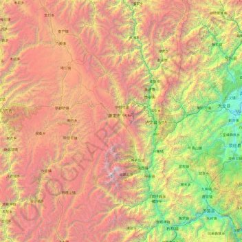
Name: 康定市 topographic map, elevation, terrain.
Location: 康定市, 甘孜藏族自治州, 四川省, 626000, 中国 (29.13707 101.00495 30.77444 102.49227)
Average elevation: 3,330 m
Minimum elevation: 658 m
Maximum elevation: 7,247 m
康定市位于四川省西部,地处横断山区东北缘, 为四川盆地和青藏高原的过渡带。折多山、贡嘎山由北向南纵贯全市,市境内海拔最高点为贡嘎山主峰7508.9米,最低点为大渡河谷1390米。境内河流密集, 有大小河流溪涧140余条。
Other topographic maps
Click on a map to view its topography, its elevation and its terrain.