
房山区 topographic map
Interactive map
Click on the map to display elevation.
About this map
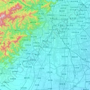
Name: 房山区 topographic map, elevation, terrain.
Location: 房山区, 北京市, 中国 (39.50584 115.41875 39.92391 116.24726)
Average elevation: 158 m
Minimum elevation: 20 m
Maximum elevation: 1,557 m
區内地形西高东低,属于暖温带大陆性季风气候。辖区总面积2019平方公里,其中平原、丘陵、山区各占三分之一。
Other topographic maps
Click on a map to view its topography, its elevation and its terrain.