
腾冲市 topographic map
Interactive map
Click on the map to display elevation.
About this map
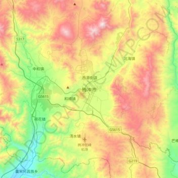
Name: 腾冲市 topographic map, elevation, terrain.
Location: 腾冲市, 保山市, 云南省, 679100, 中国 (24.86840 98.33368 25.18840 98.65368)
Average elevation: 1,770 m
Minimum elevation: 1,059 m
Maximum elevation: 2,715 m
Other topographic maps
Click on a map to view its topography, its elevation and its terrain.
西双版纳热带植物园-百竹园
西双版纳热带植物园-百竹园, 勐仑镇, 勐腊县, 西双版纳傣族自治州, 云南省, 666100, 中国
Average elevation: 559 m