
梅子湖公园 topographic map
Interactive map
Click on the map to display elevation.
About this map
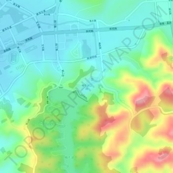
Name: 梅子湖公园 topographic map, elevation, terrain.
Location: 梅子湖公园, 南屏镇, 思茅区, 普洱市, 云南省, 中国 (22.75346 100.98253 22.75815 100.98768)
Average elevation: 1,349 m
Minimum elevation: 1,300 m
Maximum elevation: 1,442 m
Other topographic maps
Click on a map to view its topography, its elevation and its terrain.