
Make a donation
South America topographic map
Click on the map to display elevation.
Make a donation
South America
South America's topography is marked by remarkable diversity and dramatic contrasts. The continent is dominated by the Andes mountain range, which runs along its western edge, stretching over 4,300 miles from Venezuela to Chile. These mountains are home to some of the highest peaks in the Western Hemisphere, including Aconcagua, which rises to 22,841 feet. To the east of the Andes lies the expansive Amazon Basin, encompassing nearly 2.7 million square miles and characterized by dense rainforests that are teeming with biodiversity. The basin is fed by numerous tributaries, including the mighty Amazon River, which discharges vast volumes of water into the Atlantic Ocean. Meanwhile, the eastern regions feature the fertile Pampas, a vast grassland ideal for agriculture, and the semi-arid regions of Patagonia, known for its rugged terrain and sparse rainfall due to the rain shadow effect of the Andes. Notably, the Atacama Desert, situated along the Pacific coast, is recognized as the driest non-polar desert in the world, showcasing the continent's extreme climatic conditions and geographical variety.
Make a donation
About this map
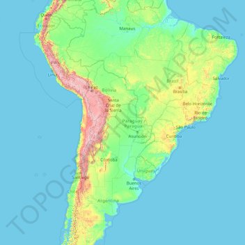
Name: South America topographic map, elevation, terrain.
Location: South America (-46.00022 -86.00066 3.99978 -36.00066)
Average elevation: 283 m
Minimum elevation: -1 m
Maximum elevation: 6,497 m
Make a donation
Other topographic maps
Click on a map to view its topography, its elevation and its terrain.
Serbia
Ancient mountains in the southeast corner of the country belong to the Rilo-Rhodope Mountain system. Elevation ranges from the Midžor peak of the Balkan Mountains at 2,169 metres (7,116 feet) (the highest peak in Serbia, excluding Kosovo) to the lowest point of just 17 metres (56 feet) near the Danube river…
Average elevation: 492 m
Nepal
Nepal is divided into three principal physiographic belts known as Himal–Pahad–Terai. Himal is the mountain region containing snow and situated in the Great Himalayan Range; it makes up the northern part of Nepal. It contains the highest elevations in the world including 8,848.86 metres (29,032 ft) height…
Average elevation: 2,604 m
Botswana
Botswana (/bɒtˈswɑːnə/ (listen), also UK: /bʊt-, bʊˈtʃw-/), officially the Republic of Botswana (Setswana: Lefatshe la Botswana, [lɪˈfatsʰɪ la bʊˈtswana]), is a landlocked country in Southern Africa. Botswana is topographically flat, with approximately 70 percent of its territory being the…
Average elevation: 1,078 m
Make a donation
Gaborone
Gaborone is situated at 24°39′29″S 25°54′44″E / 24.65806°S 25.91222°E / -24.65806; 25.91222 between Kgale and Oodi Hills, on the Notwane River in the south-eastern corner of Botswana, and 15 kilometres (9.3 mi) from the South African border. The city lies at an elevation of 1,010 metres…
Average elevation: 1,034 m
Make a donation
North-East District
Most parts of Botswana have tableland slopes sliding from east to west. It is predominantly savannah, with tall grasses, bushes, and trees. The region has an average elevation of around 915 m (3,002 ft) above sea level. The annual precipitation is around 65 cm (26 in), most of which is received during the…
Average elevation: 1,077 m
Ghanzi District
In the west, Ghanzi borders the Omaheke Region of Namibia. Domestically, it borders the following districts: North-West on the north, Central on the east, Kweneng on the southeast, Kgalagadi on the south. Ghanzi is traversed by the northwesterly line of equal latitude and longitude. This region is largely…
Average elevation: 1,071 m
Kweneng District
Kweneng is the only district without a foreign border. It borders Central District in northeast, Kgatleng District on the east, South-East District in southeast, Southern District in south, Kgalagadi District in the west, Ghanzi District in the north. The region is traversed by the northwesterly line of equal…
Average elevation: 1,083 m
North-West District
The region has an average elevation of around 915 m (3,002 ft) above the mean sea level. The vegetation type is Savannah, with tall grasses, bushes and trees. The annual precipitation is around 650 mm (26 in), most of which is received during the summer season from November to May.
Average elevation: 979 m
Make a donation
Southern District
In the south, Southern borders the North West Province of South Africa. Domestically, it borders South-East District in east, Kweneng District in north, Kgalagadi District and south west. Southern District is traversed by the northwesterly line of equal latitude and longitude. Most part of Botswana has…
Average elevation: 1,139 m
Central District
Most part of Botswana has tableland slopes sliding from east to west. The region has an average elevation of around 915 m (3,002 ft) above the mean sea level. The vegetation type is Savannah, with tall grasses, bushes and trees. The annual precipitation is around 65 cm (26 in), most of which is received during…
Average elevation: 1,006 m
Make a donation
Tunisia
Though it is relatively small in size, Tunisia has great environmental diversity due to its north–south extent. Its east–west extent is limited. Differences in Tunisia, like the rest of the Maghreb, are largely north–south environmental differences defined by sharply decreasing rainfall southward from…
Average elevation: 240 m
Make a donation
Zurich
Switzerland > Zurich > District Zurich
On its west side, the Limmat valley is flanked by the wooded heights of the Albis chain, which runs along the western border. The Uetliberg is, with 869 m (2,851 ft) above sea level, the highest elevation of the surrounding area. Its summit can be reached easily by the Uetlibergbahn. From the platform of the…
Average elevation: 499 m
Nahoon River
South Africa > Eastern Cape > Buffalo City Metropolitan Municipality > KuGompo City
Average elevation: 65 m
Make a donation
Chamonix-Mont-Blanc
France > Auvergne-Rhône-Alpes > Upper Savoy
Due to its elevation, Chamonix has a humid continental climate (Dfb, according to the Köppen climate classification), with an average annual precipitation of 1,280 mm (50 in). Summers are mild and winters are cold and snowy.
Average elevation: 2,215 m
Orange River
During the temperate months of March and April, given good rains and the sluices of the dams being open, a canoeist (or rafter) can easily travel 30 km per day. The lower reaches of the river are most popular, because of the spectacular topography. Commercial tours are available, and these expeditions depart…
Average elevation: 967 m
Make a donation
Make a donation
New Jersey
High Point in Montague Township, Sussex County is the state's highest elevation at 1,803 feet (550 m) above sea level. The state's highest prominence is Kitty Ann Mountain in Morris County, rising 892 feet (272 m). The Palisades are a line of steep cliffs on the west side of the Hudson River in Bergen and…
Average elevation: 72 m
Jordan Lake
United States > North Carolina > Chatham County
The Jordan Lake Dam (also known as the B. Everett Jordan Project and the New Hope Dam) is located at 35°39′15″N 79°4′0″W / 35.65417°N 79.06667°W / 35.65417; -79.06667 (B. Everett Jordan Dam) 4 miles (6.4 km) upstream from the mouth of the Haw River in the upper Cape Fear River drainage…
Average elevation: 102 m
Make a donation
Myanmar
In the north, the Hengduan Mountains form the border with China. Hkakabo Razi, located in Kachin State, at an elevation of 5,881 metres (19,295 ft), is the highest point in Myanmar. Many mountain ranges, such as the Rakhine Yoma, the Bago Yoma, the Shan Hills and the Tenasserim Hills exist within Myanmar, all…
Average elevation: 569 m
Borneo
Before sea levels rose at the end of the last Ice Age, Borneo was part of the mainland of Asia, forming, with Java and Sumatra, the upland regions of a peninsula that extended east from present day Indochina. The South China Sea and Gulf of Thailand now submerge the former low-lying areas of the peninsula.…
Average elevation: 141 m
Make a donation
Mutale
South Africa > Limpopo > Vhembe District Municipality > Mutale Local Municipality
Average elevation: 755 m
Make a donation
Greece
Approximately 80% of Greece consists of mountains or hills, making the country one of the most mountainous in Europe. Mount Olympus, the mythical abode of the Greek Gods, culminates at Mytikas peak 2,918 metres (9,573 ft), the highest in the country. Western Greece contains a number of lakes and wetlands and…
Average elevation: 170 m
Sheffield
Sheffield nestles on the eastern foothills of the Pennines and is sculpted by a dramatic hill-and-valley system formed where five rivers — the Don, Sheaf, Rivelin, Loxley and Porter — converge, producing steep-sided valleys and gritstone ridgelines with much of the urban area built directly onto hillsides…
Average elevation: 168 m
Jasenak
A weather station exists there at an elevation of 618 metres (2,028 ft). The minimum recorded temperature for the winter of 2024–2025 was −16.7 °C (1.9 °F), on February 20.
Average elevation: 884 m
Make a donation
Monroe County
According to the U.S. Census Bureau, the county has a total area of 680 square miles (1,800 km2), of which 549 square miles (1,420 km2) is land and 131 square miles (340 km2) (19%) is water. Monroe is Michigan's only county on Lake Erie. The River Raisin and Sandy Creek flow through the county. Sterling State…
Average elevation: 192 m
Make a donation
Rossland
Canada > British Columbia > Regional District of Kootenay Boundary
Average elevation: 1,128 m
Sweden
At 449,964 km2 (173,732 sq mi), Sweden is the 55th-largest country in the world, the fifth-largest country in Europe, and the largest country in Northern Europe. The lowest elevation in Sweden is in the bay of Lake Hammarsjön, near Kristianstad, at −2.41 m (−7.91 ft) below sea level. The highest point is…
Average elevation: 163 m
Los Angeles
United States > California > Los Angeles County
Los Angeles is characterized by a diverse and dynamic topography. The city is predominantly situated in a basin bordered by mountain ranges, including the Santa Monica Mountains to the north and the San Gabriel Mountains to the east, with elevations reaching up to about 10,000 feet (3,048 meters) in certain…
Average elevation: 241 m
Solomon Islands
The culture of Solomon Islands reflects the extent of the differentiation and diversity among the groups living within the Solomon Islands archipelago, which lies within Melanesia in the Pacific Ocean, with the peoples distinguished by island, language, topography, and geography. The cultural area includes the…
Average elevation: 7 m
Make a donation
Make a donation
Vancouver
Canada > British Columbia > Metro Vancouver Regional District
Vancouver's growing season averages 237 days, from March 18 until November 10. Vancouver's 1981–2010 USDA Plant Hardiness Zone ranges from 8a to 9a depending on elevation and proximity to water.
Average elevation: 34 m
Tamil Nadu
The region has a tropical climate and depends on monsoons for rainfall. Tamil Nadu is divided into seven agro-climatic zones: northeast, northwest, west, southern, high rainfall, high altitude hilly, and Kaveri delta. A tropical wet and dry climate prevails over most of the inland peninsular region except for…
Average elevation: 253 m
Make a donation
Dubai Emirate
Dubai lies directly in the Arabian Desert. Still, its topography differs significantly from that of the southern UAE, with much of Dubai's landscape characterized by sandy desert patterns. In contrast, gravel deserts dominate much of the country's south. The sand consists mostly of crushed shells and coral and…
Average elevation: 64 m
Uganda
Average elevation: 1,157 m
Make a donation
Scotland
Scotland's topography is a tapestry of rugged mountains, rolling hills, and expansive coastlines. The Highlands, occupying the northern and western regions, are characterized by towering peaks such as Ben Nevis, the UK's highest at 1,345 meters, and deep glens carved by ancient glaciers. The Grampian…
Average elevation: 36 m
London
London's topography is characterized by a gently rolling terrain shaped by the River Thames and its tributaries. The city lies within the London Basin, a natural depression bordered by higher grounds such as the North Downs to the south and the Chiltern Hills to the northwest. The Thames flows west to east,…
Average elevation: 66 m
Make a donation
Rio de Janeiro
The entire state is located within the tropics (the Tropic of Capricorn passes just a few kilometers south of the state's southernmost point) so a tropical climate is predominant. However, due to altitude, temperatures can drop to freezing point or below in some parts. Frost is not uncommon in some mountainous…
Average elevation: 319 m
Azerbaijan
Azerbaijan is home to a wide variety of landscapes. Over half of the land consists of mountain ridges, crests, highlands, and plateaus which rise up to levels of 400–1,000 meters (including the middle and lower lowlands), in some places (Talis, Jeyranchol-Ajinohur and Langabiz-Alat foreranges) up to…
Average elevation: 802 m
Bath
United Kingdom > England > Bath and North East Somerset
The floodplain of the Avon has an altitude of about 59 ft (18 m) above sea level, although the city centre is at an elevation of around 25 metres (82 ft) above sea level. The river, once an unnavigable series of braided streams broken up by swamps and ponds, has been managed by weirs into a single channel.…
Average elevation: 100 m
Make a donation
Make a donation
Mindanao
In the eastern portion of the island, from Bilas Point in Surigao del Norte to Cape San Agustin in Davao Oriental, is a range of complex mountains, called the Eastern Pacific Cordillera, known in their northern portion as the Diwata Mountains. This range is low and rolling in its central portion. A proposed…
Average elevation: 149 m
Make a donation
Kelowna
Canada > British Columbia > Regional District of Central Okanagan
Kelowna is classified as a humid continental climate or an inland oceanic climate per the Köppen climate classification system due to its coldest month having an average temperature slightly above −3.0 °C (26.6 °F) and below 0 °C (32 °F), with dry, hot, sunny summers and cool, cloudy winters, and four…
Average elevation: 704 m
Region Norrland
Norrland has a highly variable climate depending on altitude, latitude and distance to water. The southern coastal areas have a humid continental climate, but further north, the subarctic climate is abundant, although it in many areas is very mild for that classification, especially in coastal regions. In the…
Average elevation: 270 m
Ilmenau
Germany > Thuringia > Ilm-Kreis
Ilmenau (German pronunciation: [ˈɪlmənaʊ] ) is a town in Thuringia, central Germany. It is the largest town within the Ilm district with a population of 38,600, while the district capital is Arnstadt. Ilmenau is located approximately 33 km (21 miles) south of Erfurt and 135 km (84 miles) north of Nuremberg…
Average elevation: 604 m
Make a donation
KwaZulu-Natal
KwaZulu-Natal has a varied yet verdant climate thanks to diverse, complex topography. Generally, the coast is subtropical with inland regions becoming progressively colder. Durban on the south coast has an annual rainfall of 1009 mm, with daytime maxima peaking from January to March at 28 °C (82 °F) with a…
Average elevation: 777 m
Lincoln
United Kingdom > England > Lincolnshire
Lincoln lies at an altitude of 67 ft (20.4 m) by the River Witham up to 246 ft (75.0 m) on Castle Hill. It fills a gap in the Lincoln Cliff escarpment, which runs north and south through Central Lincolnshire, with altitudes up to 200 feet (61 metres). The city lies on the River Witham, which flows through this…
Average elevation: 29 m
Make a donation
Make a donation
Columbia River
The Deschutes River joins the Columbia near The Dalles. Between The Dalles and Portland, the river cuts through the Cascade Range, forming the dramatic Columbia River Gorge. Via the gorge, the Columbia crosses the Cascades at a lower elevation than any other river. The gorge is known for its strong and steady…
Average elevation: 1,055 m
Make a donation