
Make a donation
Gaborone topographic map
Click on the map to display elevation.
Make a donation
Gaborone
Gaborone is situated at 24°39′29″S 25°54′44″E / 24.65806°S 25.91222°E / -24.65806; 25.91222 between Kgale and Oodi Hills, on the Notwane River in the south-eastern corner of Botswana, and 15 kilometres (9.3 mi) from the South African border. The city lies at an elevation of 1,010 metres (3,310 ft) above sea level. Gaborone is surrounded by the following cities: Ramotswa to the southwest, Mogoditshane to the northwest, and Mochudi to the east, and Tlokweng across the river. Most of them are commuter towns for Gaborone. Suburbs in Gaborone include Broadhurst, Gaborone West, The Village, Naledi. Phakalane, an affluent suburb, lies about 13 km north of the city center.
Make a donation
About this map
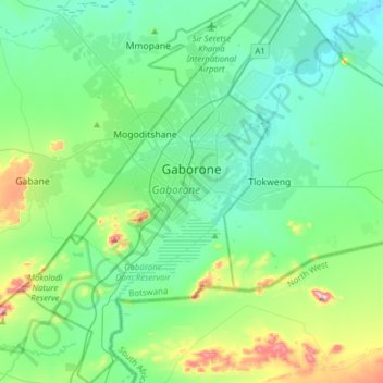
Name: Gaborone topographic map, elevation, terrain.
Location: Gaborone, Botswana (-24.81593 25.77090 -24.53454 25.98028)
Average elevation: 1,034 m
Minimum elevation: 948 m
Maximum elevation: 1,364 m
Make a donation
Other topographic maps
Click on a map to view its topography, its elevation and its terrain.
Gaborone
Botswana > South-East District
Gaborone is situated at 24°39′29″S 25°54′44″E / 24.65806°S 25.91222°E / -24.65806; 25.91222 between Kgale and Oodi Hills, on the Notwane River in the south-eastern corner of Botswana, and 15 kilometres (9.3 mi) from the South African border The city lies at an elevation of 1,010 metres…
Average elevation: 1,032 m
Make a donation
Make a donation
Maunatlala
As time passed by Kgosi Mapena’s eldest son who was named Maunatlala died, the village’ name was changed from Kopung to Maunatlala. Climatic Conditions The climate of Maunatlala area is semi-arid with dry winters and fairly wet summer months, with drought endemic. The average precipitation for the area is…
Average elevation: 878 m
Make a donation
Make a donation
Serule
Botswana > Central District > Serule
The population according to the 2001 census was 2,268 and it is estimated at more than 3000 in the latest 2011 census. The people of Serule Village comprises different ethnicities namely Bangwato, Bakwena, Batalaote, Bakalanga, Bahurutshe and its six wards are Mothoathubega, Borotsi, Mokwena, Botalaote,…
Average elevation: 935 m
Make a donation
Kalahari Desert
The climate is sub-humid rather than semi-arid in the north and east, where the dry forests, savannahs, and salt lakes prevail. South and west, where the vegetation is predominantly xeric savanna or even a semi-desert, the climate is "Kalaharian" semi-arid. The Kalaharian climate is subtropical: average annual…
Average elevation: 1,168 m
Make a donation
Otse Hill
Botswana > South-East District
Otse Hill is a peak often cited as the highest point of Botswana, with a reported altitude of 1,491 metres (4,891 feet). It is located in the village of Otse, South-East District. Its highest cell on SRTM data is 1,486 meters - 4875 feet. The 1999 Department of Surveys and Mapping (Gaborone) 1:50,000 scale…
Average elevation: 1,212 m
Make a donation
Kalahari Desert
The climate is sub-humid rather than semi-arid in the north and east, where the dry forests, savannahs, and salt lakes prevail. South and west, where the vegetation is predominantly xeric savanna or even a semi-desert, the climate is "Kalaharian" semi-arid. The Kalaharian climate is subtropical (average annual…
Average elevation: 1,168 m
Kalahari Desert
The climate is sub-humid rather than semi-arid in the north and east, where the dry forests, savannahs, and salt lakes prevail. South and west, where the vegetation is predominantly xeric savanna or even a semi-desert, the climate is "Kalaharian" semi-arid. The Kalaharian climate is subtropical: average annual…
Average elevation: 1,168 m
Make a donation
Make a donation
Make a donation
Kalahari Desert
The climate is sub-humid rather than semi-arid in the north and east, where the dry forests, savannahs, and salt lakes prevail. South and west, where the vegetation is predominantly xeric savanna or even a semi-desert, the climate is "Kalaharian" semi-arid. The Kalaharian climate is subtropical: average annual…
Average elevation: 1,168 m
Make a donation
Make a donation