
Make a donation
Ghanzi District topographic map
Click on the map to display elevation.
Make a donation
Ghanzi District
In the west, Ghanzi borders the Omaheke Region of Namibia. Domestically, it borders the following districts: North-West on the north, Central on the east, Kweneng on the southeast, Kgalagadi on the south. Ghanzi is traversed by the northwesterly line of equal latitude and longitude. This region is largely covered by the Kalahari Desert, some of which is also covered by the Makgadikgadi Pans, a large seasonal wetland. The Makgadigadi was one of the Earth's largest lakes during the Pleistocene, but currently provides a vast summer wetland to support tens of thousands of migrating flamingos in the rainy summer season. The largest town in the district is the capital Ghanzi with a population of 21,420 according to the 2011 census, which is fifteen times more than the second-largest village Ncojane has. Most part of Botswana has tableland slopes sliding from east to west. The region has an average elevation of around 550 m (1,800 ft) above the mean sea level. The vegetation type is Savannah, with tall grasses, bushes and trees on the eastern sides, but it is arid in the Central and Western regions. The annual precipitation is around 25 cm (9.8 in), most of which is received during the summer season from November to May. Most of the rivers in the region are seasonal which are prone to flash floods, being the most prominent. The tourist and game reserves in the region are Ghanzi, Central Kalahari Game Reserve, Deception Valley, Ghanzi Craft, Kgalagadi Transfrontier Park, Khutse Game Reserve and Kuru Museum and Cultural Centre.
Make a donation
About this map
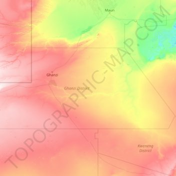
Name: Ghanzi District topographic map, elevation, terrain.
Location: Ghanzi District, Botswana (-23.32233 19.99908 -20.99537 25.44662)
Average elevation: 1,071 m
Minimum elevation: 902 m
Maximum elevation: 1,391 m
Make a donation
Other topographic maps
Click on a map to view its topography, its elevation and its terrain.
Gaborone
Botswana > South-East District
Gaborone is situated at 24°39′29″S 25°54′44″E / 24.65806°S 25.91222°E / -24.65806; 25.91222 between Kgale and Oodi Hills, on the Notwane River in the south-eastern corner of Botswana, and 15 kilometres (9.3 mi) from the South African border The city lies at an elevation of 1,010 metres…
Average elevation: 1,032 m
Make a donation
Make a donation
Maunatlala
As time passed by Kgosi Mapena’s eldest son who was named Maunatlala died, the village’ name was changed from Kopung to Maunatlala. Climatic Conditions The climate of Maunatlala area is semi-arid with dry winters and fairly wet summer months, with drought endemic. The average precipitation for the area is…
Average elevation: 878 m
Make a donation
Make a donation
Serule
Botswana > Central District > Serule
The population according to the 2001 census was 2,268 and it is estimated at more than 3000 in the latest 2011 census. The people of Serule Village comprises different ethnicities namely Bangwato, Bakwena, Batalaote, Bakalanga, Bahurutshe and its six wards are Mothoathubega, Borotsi, Mokwena, Botalaote,…
Average elevation: 935 m
Make a donation
Make a donation
Kalahari Desert
The climate is sub-humid rather than semi-arid in the north and east, where the dry forests, savannahs, and salt lakes prevail. South and west, where the vegetation is predominantly xeric savanna or even a semi-desert, the climate is "Kalaharian" semi-arid. The Kalaharian climate is subtropical: average annual…
Average elevation: 1,168 m
Kalahari Desert
The climate is sub-humid rather than semi-arid in the north and east, where the dry forests, savannahs, and salt lakes prevail. South and west, where the vegetation is predominantly xeric savanna or even a semi-desert, the climate is "Kalaharian" semi-arid. The Kalaharian climate is subtropical (average annual…
Average elevation: 1,168 m
Kalahari Desert
The climate is sub-humid rather than semi-arid in the north and east, where the dry forests, savannahs, and salt lakes prevail. South and west, where the vegetation is predominantly xeric savanna or even a semi-desert, the climate is "Kalaharian" semi-arid. The Kalaharian climate is subtropical: average annual…
Average elevation: 1,168 m
Make a donation
Otse Hill
Botswana > South-East District
Otse Hill is a peak often cited as the highest point of Botswana, with a reported altitude of 1,491 metres (4,891 feet). It is located in the village of Otse, South-East District. Its highest cell on SRTM data is 1,486 meters - 4875 feet. The 1999 Department of Surveys and Mapping (Gaborone) 1:50,000 scale…
Average elevation: 1,212 m
Make a donation
Kalahari Desert
The climate is sub-humid rather than semi-arid in the north and east, where the dry forests, savannahs, and salt lakes prevail. South and west, where the vegetation is predominantly xeric savanna or even a semi-desert, the climate is "Kalaharian" semi-arid. The Kalaharian climate is subtropical: average annual…
Average elevation: 1,168 m
Make a donation
Make a donation
Make a donation
Make a donation