Geolocate

Okavango Delta topographic map

Interactive map

Click on the map to display elevation.

About this map

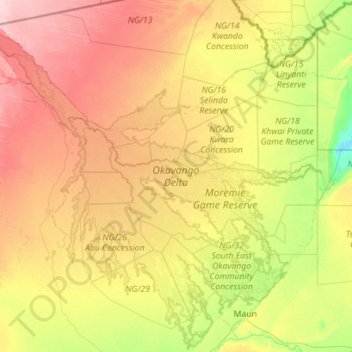
Name: Okavango Delta topographic map, elevation, terrain.

Location: Okavango Delta, North-West District, Botswana (-20.19750 21.66424 -18.11091 23.81687)

Average elevation: 955 m

Minimum elevation: 918 m

Maximum elevation: 1,098 m

Other topographic maps

Click on a map to view its topography, its elevation and its terrain.

Thamalakane River

Botswana > North-West District > Maun

Thamalakane River, Maun, North-West District, P.O. BOX 217, Botswana

Average elevation: 942 m

Shashe river

Botswana > North-West District > Maun

Shashe river, Maun, North-West District, P.O. BOX 217, Botswana

Average elevation: 941 m

Maun

Botswana > North-West District > Maun

Maun, North-West District, Botswana

Average elevation: 942 m

Shakawe

Botswana > North-West District > Shakawe

Shakawe, North-West District, Botswana

Average elevation: 1,000 m

Hambukushu

Botswana > North-West District > Hambukushu

Hambukushu, North-West District, Botswana

Average elevation: 1,017 m

Moremi Game Reserve

Botswana > North-West District

Moremi Game Reserve, North-West District, Botswana

Average elevation: 951 m

Khwai

Botswana > North-West District > Khwai

Khwai, North-West District, Botswana

Average elevation: 939 m