Geolocate

North-West District topographic map

Interactive map

Click on the map to display elevation.

North-West District

The region has an average elevation of around 915 m (3,002 ft) above the mean sea level. The vegetation type is Savannah, with tall grasses, bushes and trees. The annual precipitation is around 650 mm (26 in), most of which is received during the summer season from November to May.

Wikipedia (CC-BY-SA 3.0)

About this map

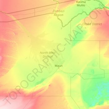
Name: North-West District topographic map, elevation, terrain.

Location: North-West District, Botswana (-21.00318 20.99886 -18.00076 25.17840)

Average elevation: 979 m

Minimum elevation: 902 m

Maximum elevation: 1,228 m

Other topographic maps

Click on a map to view its topography, its elevation and its terrain.

Gaborone

Botswana

Gaborone is situated at 24°39′29″S 25°54′44″E / 24.65806°S 25.91222°E / -24.65806; 25.91222 between Kgale and Oodi Hills, on the Notwane River in the south-eastern corner of Botswana, and 15 kilometres (9.3 mi) from the South African border. The city lies at an elevation of 1,010 metres…

Average elevation: 1,034 m

Boteti River

Botswana > Central District

Average elevation: 914 m

Maunatlala

Botswana > Central District

As time passed by Kgosi Mapena’s eldest son who was named Maunatlala died, the village’ name was changed from Kopung to Maunatlala. Climatic Conditions The climate of Maunatlala area is semi-arid with dry winters and fairly wet summer months, with drought endemic. The average precipitation for the area is…

Average elevation: 878 m

Kanye

Botswana > Southern District

Average elevation: 1,263 m

Lobatse

Botswana

Average elevation: 1,249 m

Ramotswa

Botswana > South-East District

Average elevation: 1,043 m

Khudumelapye

Botswana > Kweneng District

Average elevation: 1,071 m

Gaborone

Botswana > South-East District

Gaborone is situated at 24°39′29″S 25°54′44″E / 24.65806°S 25.91222°E / -24.65806; 25.91222 between Kgale and Oodi Hills, on the Notwane River in the south-eastern corner of Botswana, and 15 kilometres (9.3 mi) from the South African border The city lies at an elevation of 1,010 metres…

Average elevation: 1,032 m

North-East District

Botswana

Most parts of Botswana have tableland slopes sliding from east to west. It is predominantly savannah, with tall grasses, bushes, and trees. The region has an average elevation of around 915 m (3,002 ft) above sea level. The annual precipitation is around 65 cm (26 in), most of which is received during the…

Average elevation: 1,077 m

Central District

Botswana

Most part of Botswana has tableland slopes sliding from east to west. The region has an average elevation of around 915 m (3,002 ft) above the mean sea level. The vegetation type is Savannah, with tall grasses, bushes and trees. The annual precipitation is around 65 cm (26 in), most of which is received during…

Average elevation: 1,006 m

Southern District

Botswana

In the south, Southern borders the North West Province of South Africa. Domestically, it borders South-East District in east, Kweneng District in north, Kgalagadi District and south west. Southern District is traversed by the northwesterly line of equal latitude and longitude. Most part of Botswana has…

Average elevation: 1,139 m

Kgatleng District

Botswana

Average elevation: 1,120 m

Kalamare

Botswana > Central District

Average elevation: 1,212 m

Ghanzi District

Botswana

In the west, Ghanzi borders the Omaheke Region of Namibia. Domestically, it borders the following districts: North-West on the north, Central on the east, Kweneng on the southeast, Kgalagadi on the south. Ghanzi is traversed by the northwesterly line of equal latitude and longitude. This region is largely…

Average elevation: 1,071 m

Okavango Delta

Botswana > North-West District

Average elevation: 955 m

Kgope

Botswana > Kweneng District

Average elevation: 1,044 m

Kalahari Desert

Botswana > Ghanzi District

Average elevation: 1,168 m

Kgale Hill

Botswana > South-East District > Gaborone

Average elevation: 1,064 m

Kasane

Botswana > Chobe District > Kasane

Average elevation: 951 m

Letsibogo Dam

Botswana > Central District

Average elevation: 847 m

Mogoditshane

Botswana > Kweneng District > Mogoditshane

Average elevation: 1,025 m

Kweneng District

Botswana

Kweneng is the only district without a foreign border. It borders Central District in northeast, Kgatleng District on the east, South-East District in southeast, Southern District in south, Kgalagadi District in the west, Ghanzi District in the north. The region is traversed by the northwesterly line of equal…

Average elevation: 1,083 m

Palapye

Botswana > Central District

Average elevation: 927 m

Motloutse River

Botswana > Central District

Average elevation: 764 m

Notwane River

Botswana > Kgatleng District

Average elevation: 960 m

Serule

Botswana > Central District > Serule

The population according to the 2001 census was 2,268 and it is estimated at more than 3000 in the latest 2011 census. The people of Serule Village comprises different ethnicities namely Bangwato, Bakwena, Batalaote, Bakalanga, Bahurutshe and its six wards are Mothoathubega, Borotsi, Mokwena, Botalaote,…

Average elevation: 935 m

Chobe District

Botswana > Chobe District

Average elevation: 981 m

Bobonong

Botswana > Central District > Bobonong

Average elevation: 691 m

Kgatleng District

Botswana

Kgatleng borders the North West Province of South Africa in the south, and to the east it borders South Africa's Limpopo Province. Domestically, it borders South-East District in southwest, Kweneng District in the west, Central District in north. Most part of Botswana has tableland slopes sliding from east to…

Average elevation: 962 m

Tlokweng

Botswana > South-East District > Tlokweng

Average elevation: 992 m

Tutume

Botswana > Central District > Tutume

Average elevation: 1,102 m

Chobe National Park

Botswana > Chobe District

Average elevation: 964 m

Rakops

Botswana > Central District > Rakops

Average elevation: 914 m

Orapa

Botswana > Central District > Orapa

Average elevation: 972 m

Tsabong

Botswana > Kgalagadi District

Average elevation: 983 m

Hambukushu

Botswana > North-West District > Hambukushu

Average elevation: 1,017 m

Sedudu

Botswana > Chobe District

Average elevation: 982 m

Thamalakane River

Botswana > North-West District > Maun

Average elevation: 942 m

Bokaa Dam

Botswana > Kgatleng District > Mochudi

Average elevation: 958 m

Savuti

Botswana > Chobe District

Average elevation: 976 m

Chobe

Botswana > Chobe District

Average elevation: 940 m

Mosetse

Botswana > Central District

Average elevation: 1,071 m

Shashe river

Botswana > North-West District > Maun

Average elevation: 941 m

Nata river

Botswana > Central District

Average elevation: 940 m

Serorome

Botswana > Kweneng District

Average elevation: 1,003 m

Shashe Dam

Botswana > Central District

Average elevation: 969 m