
Make a donation
Portugal topographic map
Click on the map to display elevation.
Make a donation
Portugal
Portugal's topography is a diverse tapestry of rugged mountains, rolling plains, and extensive coastlines. In the north, the landscape is predominantly mountainous, with the Serra da Estrela range featuring Torre, the highest peak on mainland Portugal at 1,993 meters. This region is characterized by steep slopes and deep valleys carved by rivers such as the Douro and Mondego. Moving southward, the terrain transitions into the undulating plains of the Alentejo, marked by gentle hills and expansive agricultural fields. The southernmost region, the Algarve, boasts a varied landscape of limestone caves, grottoes, and sandy beaches along its coastline. Portugal's extensive Atlantic coastline stretches over 1,700 kilometers, featuring a mix of rugged cliffs and sandy shores. Additionally, the archipelagos of Madeira and the Azores, both autonomous regions of Portugal, are known for their volcanic origins, resulting in dramatic landscapes of craters, lakes, and lush vegetation.
Make a donation
About this map
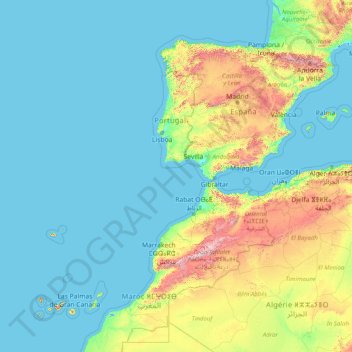
Name: Portugal topographic map, elevation, terrain.
Location: Portugal (29.82825 -31.55753 42.15431 -6.18916)
Average elevation: 268 m
Minimum elevation: -2 m
Maximum elevation: 3,622 m
Make a donation
Other topographic maps
Click on a map to view its topography, its elevation and its terrain.
Make a donation
Grand Canyon
United States > Arizona > Coconino County
Uplift associated with mountain formation later moved these sediments thousands of feet upward and created the Colorado Plateau. The higher elevation has also resulted in greater precipitation in the Colorado River drainage area, but not enough to change the Grand Canyon area from being semi-arid. The uplift…
Average elevation: 1,023 m
Nagarkot
Nepal > Bagamati Province > Kavrepalanchok
At the time of the 2021 census it had a population of 5,234 and had 1,084 houses in it. At an elevation of 2,195 meters, it is considered one of the most scenic spots in Bhaktapur District. Nagarkot also offers views of the Kathmandu Valley. The scenery of the place makes it a popular hiking route for…
Average elevation: 1,679 m
Make a donation
Kumgang Mountains
North Korea > Kangwon > Kosong County
The creation of Mt. Kŭmgang is closely related to the unique climate and distinctive geological activity of the area. Mt. Kŭmgang is a region where rain and snow fall relatively heavily, and the climate varies depending on altitude and even east-west location. The Kŭmgang geological layer is composed of…
Average elevation: 897 m
Nilambur
The 2,554 m (8,379 ft) m high Mukurthi peak, which is situated in the border of Nilambur Taluk and Ooty Taluk, and is also the fifth-highest peak in South India as well as the third-highest in Kerala after Anamudi (2,696 m [8,845 ft]) and Meesapulimala (2,651 m [8,698 ft]), is the highest point of elevation in…
Average elevation: 33 m
Make a donation
Kopaonik
Serbia > Rasina Administrative District > Brus Municipality
Kopaonik (Serbian Cyrillic: Копаоник; Albanian: Kopaoniku) is a mountain range located in Kosovo and Serbia. The highest point of this mountain range is the Pančić's Peak with an altitude of 2,017 m (6,617 ft). The central part of the Kopaonik plateau was declared a national park in 1981 which today…
Average elevation: 1,733 m
Make a donation
Malet e Sharrit / Шар Планина
The Šar Mountains are located in the south and south-east of Kosovo, where 43.12% of the range is located. Many alpine and glacial mountain lakes are found on the Kosovar part of the Šar Mountains, especially south of the town of Dragash, the area of Shutman and the region north of Vraca. The Brezovica ski…
Average elevation: 818 m
Make a donation
Mbabane
Eswatini > Hhohho Region > Inkhundla Mbabane
It has an estimated population of 94,874 (2010). It is located on the Mbabane River and its tributary the Polinjane River in the Mdzimba Mountains. It is located in the Hhohho Region, of which it is also the capital. The average elevation of the city is 1,243 meters. It lies on the MR3 road.
Average elevation: 1,138 m
Make a donation
Mount Fuji
Japan > Sunto County > Oyama
Mount Fuji (富士山・富士の山, Fujisan, Fuji no Yama) is an active stratovolcano located on the Japanese island of Honshu, with a summit elevation of 3,776.24 m (12,389 ft 3 in). It is the highest mountain in Japan, the second-highest volcano on any Asian island (after Mount Kerinci on the Indonesian…
Average elevation: 3,264 m
Make a donation
Make a donation
Pyin Oo Lwin
Pyin Oo Lwin or Pyin U Lwin (Burmese: ပြင်ဦးလွင်မြို့, MLCTS: prang u: lwang mrui., pronounced [pjɪ̀ɰ̃ ʔú lwɪ̀ɰ̃]; Shan: ဝဵင်းပၢင်ႇဢူႈ, Weng Pang U), formerly and colloquially referred to as Maymyo (Burmese: မေမြို့, MLCTS: me…
Average elevation: 913 m
Make a donation
Lalitpur
Nepal > Bagamati Province > Lalitpur
Lalitpur (Nepali: ललितपुर) is a metropolitan city and fourth most populous city of Nepal with 299,843 inhabitants living in 77,159 households per the 2021 census. It is located in the south-central part of Kathmandu Valley, a large valley in the high plateaus in central Nepal, at an altitude of…
Average elevation: 1,608 m
Make a donation
Fort Nelson
Canada > British Columbia > Northern Rockies Regional Municipality
Average elevation: 404 m
Make a donation
Make a donation
Telegraph Creek
Canada > British Columbia > Regional District of Kitimat-Stikine > Area D (Iskut/Big Raven)
Average elevation: 461 m
Make a donation
Hurulu Wewa Project Canel
Sri Lanka > North Central Province > Huruluwewa Left
Average elevation: 127 m
Make a donation
Oaxaca City
Mexico > Oaxaca > Oaxaca de Juárez
To counter this, the village petitioned the Crown for elevation to city status, which would grant it certain rights, privileges, and exceptions. It would also ensure that the settlement remained under the king's direct control, rather than Cortés's. This petition was granted in 1532 by Charles V of Spain.
Average elevation: 1,838 m
Make a donation
Make a donation
Dospat
The town was probably founded by Despot Alexius Slav in the 12th or 13th century, from whose title (despot) its name is very likely derived. Dospat Dam is the highest dam in Bulgaria by altitude and, with its 22 km2 of water area, the second largest in capacity. It is fed by the River Dospat.
Average elevation: 1,304 m
Make a donation
Ballarat
Ballarat has a moderate oceanic climate (Köppen climate classification Cfb) with four distinct seasons. Its elevation, ranging between 400 and 630 metres (1,310 and 2,070 feet) above sea level, causes its mean monthly temperatures to tend to be on average 3 to 5 °C (5 to 9 °F) below those of Melbourne,…
Average elevation: 470 m
Kaza
India > Himachal Pradesh > Spiti
Kaza, also spelled Kaze, Karze, Karzey, is a town and the subdivisional headquarters of the remote Spiti Valley in the western Himalayas in the Lahaul and Spiti district of the northern Indian state of Himachal Pradesh. Spiti is a high altitude or cold desert having close similarities to the neighbouring Tibet…
Average elevation: 4,161 m
Dan
South Africa > Limpopo > Mopani District Municipality > Greater Tzaneen Local Municipality
Average elevation: 573 m
Make a donation
Make a donation
Tzaneen Dam
South Africa > Limpopo > Mopani District Municipality > Greater Tzaneen Local Municipality
Average elevation: 721 m
Tulbagh
South Africa > Western Cape > Cape Winelands District Municipality > Witzenberg Local Municipality
Average elevation: 191 m
Make a donation
Tzaneen
South Africa > Limpopo > Mopani District Municipality > Greater Tzaneen Local Municipality
Average elevation: 737 m
Make a donation
Make a donation
Scafell Pike
United Kingdom > England > Cumberland
Scafell Pike (/ˈskɔːfɛl/) is a mountain in the Lake District region of Cumbria, England. It has an elevation of 978 metres (3,209 ft) above sea level, making it the highest and the most prominent mountain in England. The mountain is part of the Scafell massif, an extinct volcano, and is one of the Southern…
Average elevation: 679 m
Make a donation
Make a donation
Ilagan
Abuan River is the main river of the Northern Sierra Madre Natural Park. It has an average elevation of 82 meters above sea level, and feeds the Abuan watershed in the city. Tourists and visitors can explore the diverse animal and plant life in one of the country’s remaining lush virgin forests. On January…
Average elevation: 123 m
Make a donation