
Thank you for supporting this site ❤️
Make a donation
Make a donation
Oaxaca City topographic map
Click on the map to display elevation.
Thank you for supporting this site ❤️
Make a donation
Make a donation
Oaxaca City
To counter this, the village petitioned the Crown for elevation to city status, which would grant it certain rights, privileges, and exceptions. It would also ensure that the settlement remained under the king's direct control, rather than Cortés's. This petition was granted in 1532 by Charles V of Spain.
Thank you for supporting this site ❤️
Make a donation
Make a donation
About this map
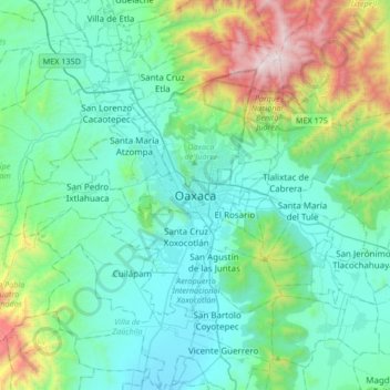
Name: Oaxaca City topographic map, elevation, terrain.
Location: Oaxaca City, Oaxaca de Juárez, Oaxaca, 68000, Mexico (16.90047 -96.88536 17.22047 -96.56536)
Average elevation: 1,838 m
Minimum elevation: 1,489 m
Maximum elevation: 3,282 m
Thank you for supporting this site ❤️
Make a donation
Make a donation