
Europe topographic map
Interactive map
Click on the map to display elevation.
Europe
Europe's topography is characterized by a striking contrast between its rugged southern mountains and the expansive plains of the north. The continent is often described as a "peninsula of peninsulas," featuring major peninsulas like the Iberian, Italian, and Balkan, each with unique geological features. In the southern regions, mountain ranges such as the Alps and the Pyrenees rise dramatically, with elevations frequently exceeding 9,800 feet (3,000 meters). Moving northward, the terrain gradually descends into the Great European Plain, a vast lowland stretching from the Pyrenees in the west to the Ural Mountains in the east, where most elevations are below 1,640 feet (500 meters). This plain is interspersed with rolling hills and valleys, making it one of the most agriculturally productive areas in Europe, while also being historically significant due to its accessibility for trade and invasion. The northern regions, including Scandinavia and the British Isles, are marked by fjords and rugged uplands, contributing to a diverse and complex landscape across the continent.
About this map
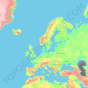
Name: Europe topographic map, elevation, terrain.
Location: Europe (26.00000 -15.00000 76.00000 35.00000)
Average elevation: 223 m
Minimum elevation: -30 m
Maximum elevation: 3,987 m
Other topographic maps
Click on a map to view its topography, its elevation and its terrain.
Serbia
Ancient mountains in the southeast corner of the country belong to the Rilo-Rhodope Mountain system. Elevation ranges from the Midžor peak of the Balkan Mountains at 2,169 metres (7,116 feet) (the highest peak in Serbia, excluding Kosovo) to the lowest point of just 17 metres (56 feet) near the Danube river…
Average elevation: 492 m
Zurich
Switzerland > Zurich > District Zurich
On its west side, the Limmat valley is flanked by the wooded heights of the Albis chain, which runs along the western border. The Uetliberg is, with 869 m (2,851 ft) above sea level, the highest elevation of the surrounding area. Its summit can be reached easily by the Uetlibergbahn. From the platform of the…
Average elevation: 499 m
Werrington
United Kingdom > England > Staffordshire > Staffordshire Moorlands
Average elevation: 218 m
Sturton le Steeple
United Kingdom > England > Nottinghamshire > Bassetlaw > Sturton le Steeple
Average elevation: 20 m
Nepal
Nepal is divided into three principal physiographic belts known as Himal–Pahad–Terai. Himal is the mountain region containing snow and situated in the Great Himalayan Range; it makes up the northern part of Nepal. It contains the highest elevations in the world including 8,848.86 metres (29,032 ft) height…
Average elevation: 2,604 m
Svrljig
Serbia > Central Serbia > Nisava Administrative District > Svrljig Municipality
Average elevation: 416 m
Solomon Islands
The culture of Solomon Islands reflects the extent of the differentiation and diversity among the groups living within the Solomon Islands archipelago, which lies within Melanesia in the Pacific Ocean, with the peoples distinguished by island, language, topography, and geography. The cultural area includes the…
Average elevation: 7 m
Boise
United States > Idaho > Ada County
Boise (locally /ˈbɔɪsi/ BOY-see) is the capital and most populous city of the U.S. state of Idaho. The population was 235,685 at the 2020 census. The Boise metropolitan area, also known as the Treasure Valley, includes five counties with an estimated population of 846,000, the most populous metropolitan…
Average elevation: 970 m
Hobart
Light frost occurs most years, though air frosts are uncommon. Although Hobart itself rarely receives snow due to the foehn effect, the adjacent kunanyi / Mount Wellington is frequently seen with a snowcap throughout the year. During the 20th century, the city itself has received snowfalls at sea level on…
Average elevation: 179 m
Yakushima
The bedrock of the island is granite, so there are no active volcanoes. The island has an area of 504.5 square kilometres (194.8 sq mi) and is roughly circular, with a circumference of 89 kilometres (55 mi) and a diameter of 28 kilometres (17 mi). Its highest elevations are Miyanouradake (宮之浦岳), at…
Average elevation: 401 m
Contra Costa County
In prehistoric times, particularly the Miocene epoch, portions of the landforms now in the area (then marshy and grassy savanna) were populated by a wide range of now extinct mammals, known in modern times by the fossil remains excavated in the southern part of the county. In the northern part of the county,…
Average elevation: 108 m
Willow Grove
United States > Pennsylvania > Montgomery County > Upper Moreland Township > Willow Grove
Average elevation: 88 m
Besançon
France > Bourgogne – Franche-Comté > Doubs
The city initially developed in a natural meander (or oxbow loop) of the river Doubs with a diameter of almost 1,000 metres (3,281 feet). The flat inner loop has an elevation of about 250 metres (820 feet), and is bounded to the south by a hill called Mont Saint-Étienne, which has a maximum height of 371…
Average elevation: 332 m
Vlaska
Serbia > Central Serbia > Pomoravlje Administrative District > Cuprija Municipality
Average elevation: 138 m
Haslemere
United Kingdom > England > Surrey > Waverley
Many of the roads in the area originated as medieval tracks and owing to the local topography, are narrow, twisting and steep. The principal route through Haslemere is the A286, which connects the town with Godalming and Grayswood (to the north) and with Midhurst (to the south). The A287 runs south from…
Average elevation: 150 m
Falmouth
United States > Massachusetts > Barnstable County
Falmouth's topography is similar to the rest of Cape Cod's, with many small ponds, creeks, and inlets surrounded by the pines and oaks of the Cape and often rocky beachfront. Falmouth's southern shore is notable for a series of ponds and rivers spaced very closely together, all of which travel some distance…
Average elevation: 7 m
Williamson County
The area is divided into two regions by the Balcones Escarpment, which runs through the center from north to south along a line from Jarrell to Georgetown to Round Rock. The county's western half is an extension of the Western Plains and considered to be within the eastern fringes of Texas Hill Country; it has…
Average elevation: 222 m
Maglic
Serbia > Vojvodina > South Backa Administrative District > Backi Petrovac Municipality
Average elevation: 83 m
Area D (Popkum/Bridal Falls/Wahleach)
Canada > British Columbia > Fraser Valley Regional District
Average elevation: 948 m
Adelaide
Australia > South Australia > Adelaide City Council
Based on the ideas of Edward Gibbon Wakefield about colonial reform, Robert Gouger petitioned the British government to create a new colony in Australia, resulting in the passage of the South Australia Act 1834. Physical establishment of the colony began with the arrival of the first British colonisers in…
Average elevation: 146 m
Ho Chi Minh City
The city is located in the south-eastern region of Vietnam, 1,760 km (1,090 mi) south of Hanoi. The average elevation is 5 m (16 ft) above sea level for the city centre and 16 m (52 ft) for the suburb areas. It borders Tây Ninh Province and Bình Dương Province to the north, Đồng Nai Province and Bà…
Average elevation: 26 m
Bahrain
Average elevation: 6 m
Duga Poljana
Serbia > Central Serbia > Zlatibor Administrative District > Sjenica Municipality
Average elevation: 1,132 m
Muntinlupa
Muntinlupa's terrain is relatively flat to sloping towards the east along the lake. Gentle rolling hills occupy the western part of the city, with elevation increasing up to 60 meters (200 ft) and above towards its southwest portion.
Average elevation: 21 m
Kisumu
Kisumu's elevation is 1,131 m (3,711 ft) and is about 320 km (200 mi) northwest of Nairobi, on the shores of Lake Victoria. It lies at the northeastern edge of the Winam Gulf, a long, shallow arm that protrudes from the main body of Lake Victoria. Kisumu is 24 km (15 mi) south of the equator and has, due to…
Average elevation: 1,310 m
Tivat
Montenegro > Tivat Municipality
Although it is the youngest town in the Boka region, Tivat has a number of tourist sites. Renaissance Summer House Buca in the centre of city, Ostrvo Cvijeća (Flowers’ Island) with sacred monuments, Gornja Lastva, the old nucleus at an altitude of 300 m (984.25 ft), the magnificent sandy beach at Plavi…
Average elevation: 60 m
Podgorica
Montenegro > Podgorica Capital City
In contrast to most of Montenegro, Podgorica lies in a mainly flat area at the northern end of the Zeta plain, at an elevation of 40 m (130 ft). The only exceptions are hills which overlook the city. The most significant is 130.3 m (427 ft) high Gorica Hill (pronounced [ˈɡǒrit͜sa]), city's namesake, which…
Average elevation: 105 m
Amarillo
United States > Texas > Potter County
Extreme temperatures range from −16 °F (−26.7 °C) on February 12, 1899 to 111 °F (43.9 °C) on June 26, 2011, but lows do not typically dip to 0 °F or −17.8 °C in most years, while highs above 100 °F or 37.8 °C are seen on 4.7 days on average. On average, there are 5.9 days of lows at or below 10…
Average elevation: 1,098 m
Bradenton
United States > Florida > Manatee County
Bradenton was affected by World War II like many other cities in Florida and the United States. During the war, Manatee County had its own Civil Defense battalion in it with two subunits existing in Bradenton and another for nearby Manatee. A recreational center was opened in March 1942 at a building on the…
Average elevation: 5 m
Žabljak
Montenegro > Žabljak Municipality
Žabljak is the seat of Žabljak Municipality (2011 population: 3,569). The town is in the centre of the Durmitor mountain region and with an altitude of 1,456 metres, it is the highest situated Balkan town.
Average elevation: 1,461 m
Baltimore
Baltimore is in north-central Maryland on the Patapsco River, close to where it empties into the Chesapeake Bay. Baltimore is located on the fall line between the Piedmont Plateau and the Atlantic coastal plain, which divides Baltimore into "lower city" and "upper city". Baltimore's elevation ranges from sea…
Average elevation: 47 m
New Jersey
High Point in Montague Township, Sussex County is the state's highest elevation at 1,803 feet (550 m) above sea level. The state's highest prominence is Kitty Ann Mountain in Morris County, rising 892 feet (272 m). The Palisades are a line of steep cliffs on the west side of the Hudson River in Bergen and…
Average elevation: 72 m
Šavnik
Montenegro > Šavnik Municipality
Šavnik (Cyrillic: Шавник, pronounced [ʃǎv̞niːk]) is a town in Montenegro in the northern region and administrative center of the Šavnik Municipality. It is located at the confluence of three rivers - Bukovica, Bijela and Šavnik, at an altitude of 840 meters. It is the lowest lying settlement in…
Average elevation: 1,021 m