
Thank you for supporting this site ❤️
Make a donation
Make a donation
Yingde topographic map
Click on the map to display elevation.
Thank you for supporting this site ❤️
Make a donation
Make a donation
About this map
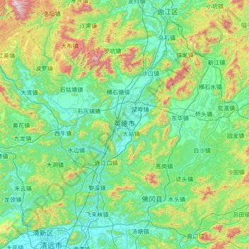
Name: Yingde topographic map, elevation, terrain.
Location: Yingde, Qingyuan City, Guangdong Province, 513000, China (23.84577 112.75519 24.55255 113.92617)
Average elevation: 284 m
Minimum elevation: 5 m
Maximum elevation: 1,646 m
Thank you for supporting this site ❤️
Make a donation
Make a donation
Other topographic maps
Click on a map to view its topography, its elevation and its terrain.
Thank you for supporting this site ❤️
Make a donation
Make a donation
Thank you for supporting this site ❤️
Make a donation
Make a donation
Pubian
China > Guangdong Province > Fengkai County > Zhaoqing City > Jiangchuan
Average elevation: 43 m
Thank you for supporting this site ❤️
Make a donation
Make a donation
Thank you for supporting this site ❤️
Make a donation
Make a donation
Thank you for supporting this site ❤️
Make a donation
Make a donation
Thank you for supporting this site ❤️
Make a donation
Make a donation
Thank you for supporting this site ❤️
Make a donation
Make a donation
Thank you for supporting this site ❤️
Make a donation
Make a donation
Thank you for supporting this site ❤️
Make a donation
Make a donation
Thank you for supporting this site ❤️
Make a donation
Make a donation
Thank you for supporting this site ❤️
Make a donation
Make a donation
Tianchi (Heaven Lake)
China > Guangdong Province > Chao'an District > Fenghuang
Average elevation: 1,053 m
Thank you for supporting this site ❤️
Make a donation
Make a donation
Thank you for supporting this site ❤️
Make a donation
Make a donation
Thank you for supporting this site ❤️
Make a donation
Make a donation