
Mormugao topographic map
Interactive map
Click on the map to display elevation.
About this map
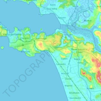
Name: Mormugao topographic map, elevation, terrain.
Location: Mormugao, South Goa, India (15.32368 73.78321 15.41886 73.95739)
Average elevation: 17 m
Minimum elevation: -2 m
Maximum elevation: 178 m
Other topographic maps
Click on a map to view its topography, its elevation and its terrain.
Varanasi
India > Uttar Pradesh > Sadar
Varanasi is located at an elevation of 80.71 metres (264.8 ft) in the centre of the Ganges valley of North India, in the Eastern part of the state of Uttar Pradesh, along the left crescent-shaped bank of the Ganges, averaging between 15 metres (50 ft) and 21 metres (70 ft) above the river. The city is the…
Average elevation: 77 m
Chittoor
India > Andhra Pradesh > Chittoor
It is located between the northern latitudes of 37" and 14°8" and between the eastern longitudes 78°33" and 79°55". It is bounded on the east by Tirupati district of Andhra Pradesh, on the south by Krishnagiri District , Vellore, Tiruvallur,Thirupattur districts of Tamil Nadu, on the west by Kolar district…
Average elevation: 350 m
Chandoli National Park
India > Maharashtra > Shirala
The park spreads along the crest of the Sahyadri Range of the northern Western Ghats. It forms and protects many perennial water channels, water holes and the Vasant Sagar Reservoir. Elevation of the park ranges from 589–1,044 m (1,932–3,425 ft). The park receives its water supply from the Warna river and…
Average elevation: 749 m
Auroville
India > Tamil Nadu > Vanur
It is included in the sub-humid tropics (wet-and-dry tropical climate) situated on a plateau region with its maximum elevation of 32 m (105 ft) above sea level located in the Matrimandir area. The annual rainfall average is 1,200 mm (47 in) mainly from the SW monsoon (June to Sept.) and NE monsoon (Nov to Dec)…
Average elevation: 36 m
Bagalkote
India > Karnataka > Bagalakote taluk
Bagalakote, is a city in the state of Karnataka, India, which is also the headquarters of Bagalakote district. It is situated on branch of River Ghataprabha about 481 km (299 mi) northwest of state capital Bengaluru, 410 km (255 mi) southwest of Hyderabad, and about 570 km (354 mi) southeast of Mumbai. The…
Average elevation: 556 m
Sliding Rock
India > Andhra Pradesh > Kurabalakota > Mandemvaripalli > Sriramavaripalli
Average elevation: 740 m
Palanpur
India > Gujarat > Palanpur Taluka
Palanpur is located at 24°06′N 72°15′E / 24.10°N 72.25°E / 24.10; 72.25. It has an average elevation of 209 metres (685 ft).
Average elevation: 218 m
Badami
India > Karnataka > Badami taluku
Badami is located at 15°55′N 75°41′E / 15.92°N 75.68°E / 15.92; 75.68. It has an average elevation of 586 metres (1922 ft). It is located at the mouth of a ravine between two rocky hills and surrounds Agastya tirtha water reservoir on the three other sides. The total area of the town is 10.3…
Average elevation: 587 m
Bengaluru
India > Karnataka > Bangalore North > Bengaluru
Bangalore (/bæŋɡəˈlɔːr/), officially known as Bengaluru (Kannada pronunciation: (listen)), is the capital and the largest city of the Indian state of Karnataka. It has a population of more than 8 million and a metropolitan population of around 11 million, making it the third most populous city and fifth…
Average elevation: 879 m
Leh
Leh is located at an average elevation of about 3500 metres, which means that only one crop a year can be grown there, while two can be grown at Khalatse. By the time crops are being sown at Leh in late May, they are already half-grown at Khalatse. The main crop is grim (naked barley - Hordeum vulgare L. var.…
Average elevation: 4,294 m
Mangaluru
India > Karnataka > Mangaluru taluk
Mangalore is included as one of the cities in the Smart Cities Mission list and is among the 100 smart cities to be developed in India. It has an average elevation of 22 m (72 ft) above mean sea level. It has a tropical monsoon climate and is under the influence of the southwest monsoon. It has its own…
Average elevation: 25 m
Ujjain
India > Madhya Pradesh > Ujjain
Ujjain is located in the west-central part of India, and is north of the upper limit of the Vindhya mountain ranges. Located on the Malwa plateau, it is higher than the north Indian plains and the land rises towards the Vindhya Range to the south. Ujjain's co-ordinates are 23°10′N 75°46′E /…
Average elevation: 502 m
Chittaranjan
India > West Bengal > Chittaranjan
Chittaranjan is located at 23°52′N 86°52′E / 23.87°N 86.87°E / 23.87; 86.87. It has an average elevation of 155 metres (508 feet).
Average elevation: 156 m
Roorkee
India > Uttarakhand > Roorkee > Roorkee
Roorkee is located at 29°52′N 77°53′E / 29.87°N 77.88°E / 29.87; 77.88. It has an average elevation of 268 metres (879 feet).
Average elevation: 270 m
Dehradun
India > Uttarakhand > Dehradun
The city of Dehradun mainly lies in Doon Valley and is at a varying height from 410 m in Clement Town to above 700 m at Malsi which is 15 km from the city. However, the average elevation is 450 m above sea level. Malsi is the starting point of Lesser Himalayan Range that extends to Mussoorie and beyond.…
Average elevation: 904 m
Darjeeling
India > West Bengal > Darjeeling
Darjeeling (Bengali: , Nepali: ) is a city and a municipality in the Indian state of West Bengal. It is located in the Lesser Himalayas at an elevation of 2,000 metres (6,700 ft). It is noted for its tea industry, its views of Kangchenjunga, the world's third-highest mountain, and the Darjeeling Himalayan…
Average elevation: 1,331 m
Kalimpong
India > West Bengal > Kalimpong
Kalimpong is a city and a municipality in the Indian state of West Bengal. It is located at an average elevation of 1,250 metres (4,101 ft). The city is the headquarters of the Kalimpong district. Kalimpong district region comes under Gorkhaland Territorial Administration which is an autonomous governing body…
Average elevation: 838 m
Secunderabad
India > Telangana > Secunderabad
Situated in the North of Hyderabad at 17°27′N 78°30′E / 17.45°N 78.5°E / 17.45; 78.5., Secunderabad lies on the northern part of the Deccan Plateau. Secunderabad has an average elevation of 543 metres (1781 ft). Most of the area has a rocky terrain and some areas are hilly.
Average elevation: 544 m