
Thank you for supporting this site ❤️
Make a donation
Make a donation
Bharmour topographic map
Click on the map to display elevation.
Thank you for supporting this site ❤️
Make a donation
Make a donation
About this map
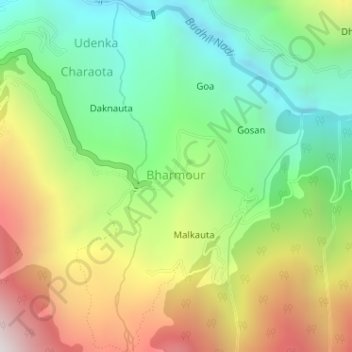
Name: Bharmour topographic map, elevation, terrain.
Location: Bharmour, Brahmaur, Chamba, Himachal Pradesh, 176315, India (32.43996 76.53340 32.44322 76.53946)
Average elevation: 2,204 m
Minimum elevation: 1,626 m
Maximum elevation: 3,046 m
Thank you for supporting this site ❤️
Make a donation
Make a donation