
Mangaluru topographic map
Interactive map
Click on the map to display elevation.
About this map
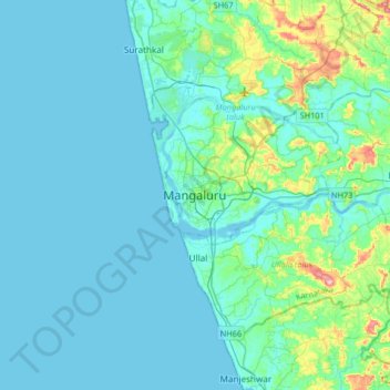
Name: Mangaluru topographic map, elevation, terrain.
Average elevation: 25 m
Minimum elevation: -2 m
Maximum elevation: 205 m
Mangalore is also the administrative headquarters of the Dakshina Kannada district, and is one of India's most multicultural and multi-linguistic cities, and is a commercial, industrial, educational, healthcare and startup hub. This city's International Airport is the second-largest airport in Karnataka. The Mangalore urban agglomeration extends from Ullal in the south to Surathkal in the north, a distance of over 30 km (19 mi). The city extends eastwards to Vamanjoor, Deralakatte, Padil and Bajpe. The city's landscape is characterised by rolling hills, coconut palms, freshwater streams and hard, red-clay-roofed buildings. India's first 3D planetarium with 8K resolution display is situated in this city. Mangalore is also included in the Smart Cities Mission list and is among the 100 smart cities to be developed in India. The city has an average elevation of 22 m (72 ft) above mean sea level. Mangalore has a tropical monsoon climate and is under the influence of the southwest monsoon.