
Thank you for supporting this site ❤️
Make a donation
Make a donation
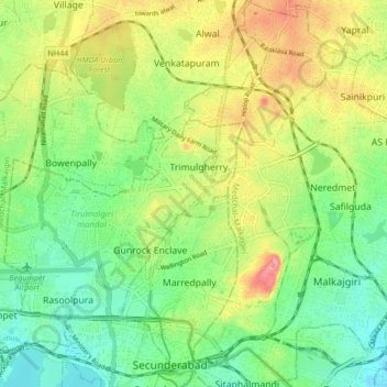
Secunderabad topographic map
Click on the map to display elevation.
Thank you for supporting this site ❤️
Make a donation
Make a donation
Secunderabad
Situated in the North of Hyderabad at 17°27′N 78°30′E / 17.45°N 78.5°E / 17.45; 78.5., Secunderabad lies on the northern part of the Deccan Plateau. Secunderabad has an average elevation of 543 metres (1781 ft). Most of the area has a rocky terrain and some areas are hilly.
Thank you for supporting this site ❤️
Make a donation
Make a donation
About this map
Name: Secunderabad topographic map, elevation, terrain.
Average elevation: 544 m
Minimum elevation: 446 m
Maximum elevation: 634 m
Thank you for supporting this site ❤️
Make a donation
Make a donation