
Thank you for supporting this site ❤️
Make a donation
Make a donation
Badami topographic map
Click on the map to display elevation.
Thank you for supporting this site ❤️
Make a donation
Make a donation
Badami
Badami is located at 15°55′N 75°41′E / 15.92°N 75.68°E / 15.92; 75.68. It has an average elevation of 586 metres (1922 ft). It is located at the mouth of a ravine between two rocky hills and surrounds Agastya tirtha water reservoir on the three other sides. The total area of the town is 10.3 square kilometers.
Thank you for supporting this site ❤️
Make a donation
Make a donation
About this map
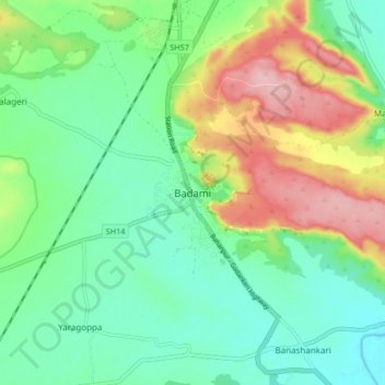
Name: Badami topographic map, elevation, terrain.
Average elevation: 587 m
Minimum elevation: 527 m
Maximum elevation: 706 m
Thank you for supporting this site ❤️
Make a donation
Make a donation