
Thank you for supporting this site ❤️
Make a donation
Make a donation
Negombo topographic map
Click on the map to display elevation.
Thank you for supporting this site ❤️
Make a donation
Make a donation
About this map
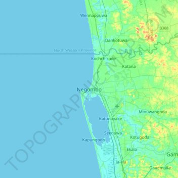
Name: Negombo topographic map, elevation, terrain.
Location: Negombo, Gampaha District, Western Province, 11500, Sri Lanka (7.04943 79.67312 7.36943 79.99312)
Average elevation: 8 m
Minimum elevation: 0 m
Maximum elevation: 68 m
Thank you for supporting this site ❤️
Make a donation
Make a donation