
Morocco topographic map
Interactive map
Click on the map to display elevation.
Morocco
In the Rif, Middle and High Atlas Mountains, there exist several different types of climates: Mediterranean along the coastal lowlands, giving way to a humid temperate climate at higher elevations with sufficient moisture to allow for the growth of different species of oaks, moss carpets, junipers, and Atlantic fir which is a royal conifer tree endemic to Morocco. In the valleys, fertile soils and high precipitation allow for the growth of thick and lush forests. Cloud forests can be found in the west of the Rif Mountains and Middle Atlas Mountains. At higher elevations, the climate becomes alpine in character, and can sustain ski resorts.
About this map
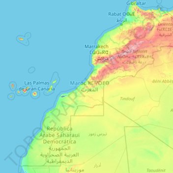
Name: Morocco topographic map, elevation, terrain.
Location: Morocco (20.66725 -17.31902 36.00214 -0.99843)
Average elevation: 277 m
Minimum elevation: -57 m
Maximum elevation: 4,026 m
Other topographic maps
Click on a map to view its topography, its elevation and its terrain.
Toubkal
Morocco > cercle d'Asni > Asni
Toubkal, also Jbel Toubkal or Jebel Toubkal, is a mountain in southwestern Morocco, located in the Toubkal National Park. At 4,167 m (13,671 ft), it is the highest peak in Morocco, the Atlas Mountains, North Africa and the Arab world. Located 63 km (39 mi) south of the city of Marrakesh, and visible from it,…
Average elevation: 3,616 m
Dakhla-Oued Ed-Dahab
Morocco > Oum Dreyga ⵓⵎ ⴷⵔⵉⴳⴰ أم ادريكة
Topography of Western Sahara.
Average elevation: 301 m