
Thank you for supporting this site ❤️
Make a donation
Make a donation
Brantley County topographic map
Click on the map to display elevation.
Thank you for supporting this site ❤️
Make a donation
Make a donation
About this map
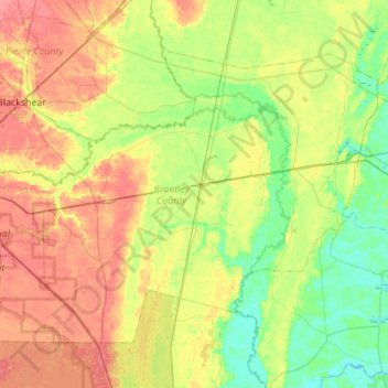
Name: Brantley County topographic map, elevation, terrain.
Location: Brantley County, Georgia, United States (31.01063 -82.28433 31.37325 -81.73169)
Average elevation: 22 m
Minimum elevation: -1 m
Maximum elevation: 52 m
Thank you for supporting this site ❤️
Make a donation
Make a donation
Other topographic maps
Click on a map to view its topography, its elevation and its terrain.
Worley Crossroads
United States > Georgia > Cherokee County > Worley Crossroads
Average elevation: 378 m