
阔达藏族乡 topographic map
Interactive map
Click on the map to display elevation.
About this map
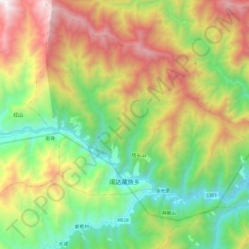
Name: 阔达藏族乡 topographic map, elevation, terrain.
Location: 阔达藏族乡, 平武县, 绵阳市, 四川省, 中国 (32.43272 104.33043 32.57198 104.51000)
Average elevation: 1,842 m
Minimum elevation: 922 m
Maximum elevation: 3,304 m
Other topographic maps
Click on a map to view its topography, its elevation and its terrain.