Pennsylvania topographic map
Interactive map
Click on the map to display elevation.
Pennsylvania
Pennsylvania's diverse topography produces a variety of climates, though the entire state experiences cold winters and humid summers. Straddling two major zones, the majority of the state, except for the southeastern corner, has a humid continental climate (Köppen climate classification Dfb). The southern portion of the state has a humid subtropical climate. The largest city, Philadelphia, has a humid subtropical climate (Köppen Cfa).
About this map
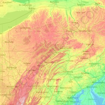
Name: Pennsylvania topographic map, elevation, terrain.
Location: Pennsylvania, United States (39.71977 -80.52109 42.51613 -74.68967)
Average elevation: 340 m
Minimum elevation: -3 m
Maximum elevation: 1,418 m
Other topographic maps
Click on a map to view its topography, its elevation and its terrain.
Contra Costa County
In prehistoric times, particularly the Miocene epoch, portions of the landforms now in the area (then marshy and grassy savanna) were populated by a wide range of now extinct mammals, known in modern times by the fossil remains excavated in the southern part of the county. In the northern part of the county,…
Average elevation: 108 m
Lake Koon
United States > Pennsylvania > Bedford County > Cumberland Valley Township
Average elevation: 366 m
Mount Shasta
United States > California > Siskiyou County
Mount Shasta (/ˈʃæstə/ SHASS-tə; Shasta: Waka-nunee-Tuki-wuki; Karuk: Úytaahkoo) is a potentially active stratovolcano at the southern end of the Cascade Range in Siskiyou County, California. At an elevation of 14,179 ft (4,322 m), it is the second-highest peak in the Cascades and the fifth-highest in…
Average elevation: 3,717 m
Indian Springs
United States > Nevada > Clark County > Indian Springs
One year later, Indian Springs was reactivated as Indian Springs Air Force Base by the new United States Air Force, with a new role as a new weapons systems and aircraft research and testing. Among these missions were support for nuclear arms testing at the Nevada Proving Grounds, high-altitude balloon search…
Average elevation: 1,078 m
Big Sky
United States > Montana > Gallatin County
Big Sky is located along the western edge of Gallatin County and eastern edge of Madison County at 45°16′12″N 111°17′59″W / 45.269940°N 111.299725°W / 45.269940; -111.299725 (45.269940, -111.299725), approximately midway between West Yellowstone and Bozeman on U.S. Highway 191 and 30 miles…
Average elevation: 2,435 m
Park City
United States > Utah > Summit County
In the summertime, many valley residents of the Wasatch Front visit the town to escape high temperatures. Park City is usually cooler than Salt Lake City as it lies mostly higher than 7,000 feet (2,100 m) above sea level, while Salt Lake City is situated at an elevation of about 4,300 feet (1,300 m).
Average elevation: 2,290 m
Florida
Economic prosperity in the 1920s stimulated tourism to Florida and related development of hotels and resort communities. Combined with its sudden elevation in profile was the Florida land boom of the 1920s, which brought a brief period of intense land development. In 1925, the Seaboard Air Line broke the FEC's…
Average elevation: 6 m
Berwick
United States > Maine > York County
According to the United States Census Bureau, the town has a total area of 37.86 square miles (98.06 km2), of which 37.52 square miles (97.18 km2) is land and 0.34 square miles (0.88 km2) is water. Berwick is drained by the Little River and Salmon Falls River. Diamond Hill, at an elevation of 490 feet (149.4…
Average elevation: 76 m
City of Binghamton
United States > New York > Broome County
Binghamton, like all of the Southern Tier of New York, lies on the Allegheny Plateau; hence its hilly terrain. As such, elevations can vary in the city--Downtown, for example, is at an elevation of around 860 feet (262 meters), while residential homes in the hills can go up to over 1,800 feet (548 meters),…
Average elevation: 321 m
Imperial County
Fort Yuma is located on the banks of the Colorado River in Winterhaven, California. First established after the end of the Mexican–American War in 1848, it was originally located in the bottoms near the Colorado River, less than 1 mile (1.6 km) below the mouth of the Gila River. It was to defend the newly…
Average elevation: 190 m
Niihau
United States > Hawaii > Kauaʻi County > Puuwai
Niʻihau is located about 18 miles (29 km) west of Kauaʻi, and the tiny, uninhabited island of Lehua lies 0.7 miles (0.61 nmi; 1.1 km) north of Niʻihau. Niʻihau's dimensions are 6.2 miles by 18.6 miles (10 km × 30 km). The maximum elevation (Paniau) is 1,280 feet (390 m). The island is about 6 million…
Average elevation: 23 m
Delaware
Delaware is on a level plain, with the lowest mean elevation of any state in the nation. Its highest elevation, located at Ebright Azimuth, near Concord High School, is less than 450 feet (140 m) above sea level. The northernmost part of the state is part of the Piedmont Plateau with hills and rolling surfaces.
Average elevation: 16 m
Bentonville
United States > Arkansas > Benton County
Bentonville shares many of the characteristics commonly given to Arkansas as a Southern state, yet it has also absorbed minor cultural influence from the Midwest and West. Located firmly in the Mid-South, Bentonville's culture is distinct and differs from the Delta portion of the state. Many of the city's…
Average elevation: 387 m
New Orleans
United States > Louisiana > Orleans Parish
Founded in 1718 by French colonists, New Orleans was once the territorial capital of French Louisiana before becoming part of the United States in the Louisiana Purchase of 1803. New Orleans in 1840 was the third most populous city in the United States, and it was the largest city in the American South from…
Average elevation: 1 m
Charlotte
United States > North Carolina > Mecklenburg County
According to the United States Census Bureau, the city has a total area of 312.00 square miles (808.1 km2), of which 310.02 square miles (802.9 km2) is land and 1.98 square miles (5.1 km2) (0.63%) is water. Charlotte is the twenty-sixth-most expansive city in the United States and lies at an elevation of 751…
Average elevation: 207 m
San Antonio
United States > Texas > Bexar County
San Antonio is approximately 75 miles (121 km) to the southwest of its neighboring city, Austin, the state capital, about 150 miles (240 km) from the Mexico-United States border, about 190 miles (310 km) west of Houston, and about 250 miles (400 km) south of the Dallas–Fort Worth area. The city has a total…
Average elevation: 247 m
Utah Lake
United States > Utah > Utah County
Utah Lake is a shallow freshwater lake in the center of Utah County, Utah, United States. It lies in Utah Valley, surrounded by the Provo-Orem metropolitan area. The lake's only river outlet, the Jordan River, is a tributary of the Great Salt Lake. Evaporation accounts for 42% of the lake's outflow, which…
Average elevation: 1,512 m
Nashville-Davidson
United States > Tennessee > Davidson County
Nashville lies on the Cumberland River in the northwestern portion of the Nashville Basin. Nashville's elevation ranges from its lowest point, 385 feet (117 m) above sea level at the Cumberland River, to its highest point, 1,163 feet (354 m) above sea level in the Radnor Lake State Natural Area. Nashville also…
Average elevation: 184 m
Blue Ridge Parkway
United States > North Carolina > Watauga County
The parkway has been the most visited unit of the National Park System every year since 1946 except four (1949, 2013, 2016 and 2019). Land on either side of the road is owned and maintained by the National Park Service, and in many places parkway land is bordered by United States Forest Service property. There…
Average elevation: 504 m
Hancock
United States > New Hampshire > Hillsborough County
According to the United States Census Bureau, the town has a total area of 31.2 square miles (80.9 km2), of which 30.0 square miles (77.6 km2) are land and 1.3 square miles (3.3 km2) are water, comprising 4.12% of the town. Hancock is drained by the Contoocook River, which flows northward along the eastern…
Average elevation: 300 m
Pinellas County
Elevation in the county ranges from mean sea level to its highest natural point of 110 feet (34 m) near the intersection of SR 580 and Countryside Blvd. in Clearwater. Due to its small size and high population, by the early 21st century Pinellas County has been mostly built out, with very little developable…
Average elevation: 4 m
Encinitas
Encinitas lies on a rugged coastal terrace. The city is bisected by a low-lying coastal ridge that separates New and Old Encinitas. In the north of the city, the coast rises in elevation and the land is raised up in the form of many coastal bluffs, which are subject to collapsing on the narrow beach. The city…
Average elevation: 32 m
Milford
United States > Connecticut > South Central Connecticut Planning Region
Average elevation: 18 m
Vermont
The topography and climate make sections of Vermont subject to large-scale flooding. Incidents include the Great Vermont Flood of 1927, which killed 84 and damaged much of the state's infrastructure, the flood of 1973, which covered many of the state's roads in the southeast, and Tropical Storm Irene in 2011,…
Average elevation: 348 m
Rindge
United States > New Hampshire > Cheshire County
According to the United States Census Bureau, the town has a total area of 39.8 square miles (103.1 km2), of which 37.1 square miles (96.1 km2) are land and 2.7 square miles (7.0 km2) are water, comprising 6.76% of the town. Rindge is located in a hilly upland lake region. Hubbard Pond is in the northeast,…
Average elevation: 343 m
New Hampshire
Average daytime highs are in the mid 70s°F to low 80s°F (24–28 °C) throughout the state in July, with overnight lows in the mid 50s°F to low 60s°F (13–15 °C). January temperatures range from an average high of 34 °F (1 °C) on the coast to overnight lows below 0 °F (−18 °C) in the far north and…
Average elevation: 293 m
South Orange
United States > New Jersey > Essex County
The western part of the town sits on the eastern slope of South Mountain (elevation <660 feet (200 m)), leveling into a small valley near the central business district. At the top of the slope, the western edge of the town runs along the eastern border of South Mountain Reservation. South Orange contains the…
Average elevation: 94 m