
Thank you for supporting this site ❤️
Make a donation
Make a donation
Alamo topographic map
Click on the map to display elevation.
Thank you for supporting this site ❤️
Make a donation
Make a donation
About this map
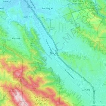
Name: Alamo topographic map, elevation, terrain.
Average elevation: 197 m
Minimum elevation: 47 m
Maximum elevation: 616 m
Thank you for supporting this site ❤️
Make a donation
Make a donation
Other topographic maps
Click on a map to view its topography, its elevation and its terrain.
Orinda
United States > California > Contra Costa County > Orinda
The area is characterized by a warm-summer Mediterranean climate (Köppen climate classification Csb) with cool, rainy winters and warm, dry summers. Because Orinda is located in a hilly area, microclimates often dominate temperature differences in short distances. The Oakland Hills often block the cool foggy…
Average elevation: 246 m
Thank you for supporting this site ❤️
Make a donation
Make a donation