
桂林市 topographic map
Interactive map
Click on the map to display elevation.
About this map
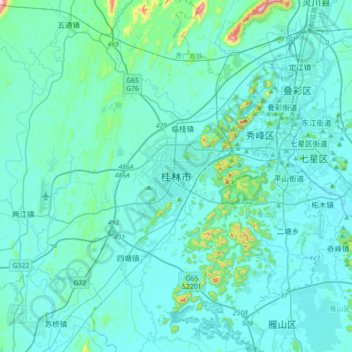
Name: 桂林市 topographic map, elevation, terrain.
Location: 桂林市, 广西壮族自治区, 中国 (25.07870 110.01507 25.39870 110.33507)
Average elevation: 177 m
Minimum elevation: 138 m
Maximum elevation: 591 m
桂林属典型的喀斯特地貌石灰岩地形,大部分为丘陵,北部和东部分别为越城岭和海洋山、都庞岭山区,有很多面积较小的山间盆地。桂林市区坐落在湘桂走廊中的一个相对较大的平原里。桂林市南部有破碎的丘陵平原,西部、北部和东部是大面积的山地。猫儿山海拔2142米,称“华南第一峰”。
Other topographic maps
Click on a map to view its topography, its elevation and its terrain.