
察哈尔右翼前旗 topographic map
Interactive map
Click on the map to display elevation.
About this map
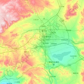
Name: 察哈尔右翼前旗 topographic map, elevation, terrain.
Location: 察哈尔右翼前旗, 乌兰察布市, 内蒙古自治区, 中国 (40.68606 112.80654 41.20721 113.66313)
Average elevation: 1,514 m
Minimum elevation: 1,229 m
Maximum elevation: 2,059 m
Other topographic maps
Click on a map to view its topography, its elevation and its terrain.