
商都县 topographic map
Interactive map
Click on the map to display elevation.
About this map
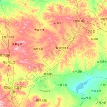
Name: 商都县 topographic map, elevation, terrain.
Location: 商都县, 乌兰察布市, 内蒙古自治区, 中国 (41.29306 113.12424 42.14150 114.24887)
Average elevation: 1,450 m
Minimum elevation: 1,272 m
Maximum elevation: 1,767 m
Other topographic maps
Click on a map to view its topography, its elevation and its terrain.