
察哈尔右翼中旗 topographic map
Interactive map
Click on the map to display elevation.
About this map
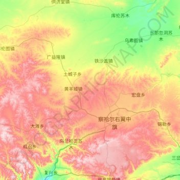
Name: 察哈尔右翼中旗 topographic map, elevation, terrain.
Location: 察哈尔右翼中旗, 乌兰察布市, 内蒙古自治区, 013500, 中国 (41.01904 111.92503 41.82535 112.85642)
Average elevation: 1,674 m
Minimum elevation: 1,308 m
Maximum elevation: 2,203 m
Other topographic maps
Click on a map to view its topography, its elevation and its terrain.