
百色市 topographic map
Interactive map
Click on the map to display elevation.
About this map
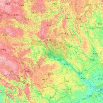
Name: 百色市 topographic map, elevation, terrain.
Location: 百色市, 广西壮族自治区, 中国 (22.85575 104.44824 25.10213 107.88300)
Average elevation: 688 m
Minimum elevation: 62 m
Maximum elevation: 2,177 m
百色位于廣西西部。由於地勢西高東低,因此百色東西兩地气温差别很大。百色東部属南亚热带季风气候,气候温暖。冬季短暂温和,夏季漫长炎热。冬季干燥,日照少。夏秋季节多晴朗天气。1月平均气温13.4℃,极端最低气温-2.0℃(1955年1月12日)。7月平均气温28.4℃,极端最高气温42.5℃(1958年4月23日)。年平均气温22.0℃。降雨主要集中在5月~8月。年均降水量1070.6毫米。而百色西部由於是地處雲貴高原東緣,地勢平均高於海拔500米,而隆林縣和西林縣一帶更高於海拔1000米。氣候情況與雲南省中部大部份城市相若,全年溫差較少而氣溫偏低。
Other topographic maps
Click on a map to view its topography, its elevation and its terrain.
岑王老山国家级自然保护区
岑王老山国家级自然保护区, 浪平镇, 田林县, 百色市, 广西壮族自治区, 中国
Average elevation: 1,236 m