
三乡镇 topographic map
Interactive map
Click on the map to display elevation.
About this map
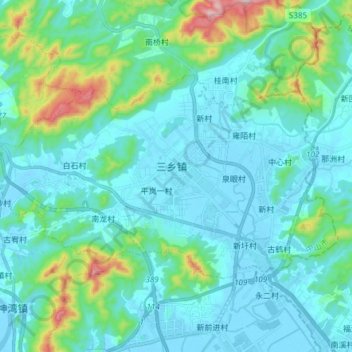
Name: 三乡镇 topographic map, elevation, terrain.
Location: 三乡镇, 中山市, 广东省, 528463, 中国 (22.31302 113.34689 22.39438 113.49837)
Average elevation: 80 m
Minimum elevation: -7 m
Maximum elevation: 504 m
三鄉鎮境丘陵與沖積平原相間,山嶺環列。東有大尖嶺,北有馬坑山、北邊山,西有加林山,西南有白水林山(又名竹篙嶺),南有五指山。山地面積40平方公里。白水林山海拔473米,為全鎮最高點,全市第二高山。中部為平地,南部為沖積平原。茅灣湧縱貫鎮境東部,長11公里,北接鴉崗運河。
Other topographic maps
Click on a map to view its topography, its elevation and its terrain.