
五桂山街道 topographic map
Interactive map
Click on the map to display elevation.
About this map
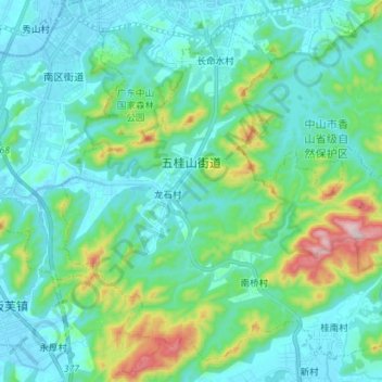
Name: 五桂山街道 topographic map, elevation, terrain.
Location: 五桂山街道, 中山市, 广东省, 中国 (22.38061 113.34854 22.49721 113.49006)
Average elevation: 95 m
Minimum elevation: -7 m
Maximum elevation: 505 m
Other topographic maps
Click on a map to view its topography, its elevation and its terrain.