
Nepal topographic map
Click on the map to display elevation.
Nepal
Nepal is divided into three principal physiographic belts known as Himal–Pahad–Terai. Himal is the mountain region containing snow and situated in the Great Himalayan Range; it makes up the northern part of Nepal. It contains the highest elevations in the world including 8,848.86 metres (29,032 ft) height Mount Everest (Sagarmāthā in Nepali) on the border with China. Seven other of the world's "eight-thousanders" are in Nepal or on its border with Tibet: Lhotse, Makalu, Cho Oyu, Kangchenjunga, Dhaulagiri, Annapurna and Manaslu. Pahad is the mountain region that does not generally contain snow. The mountains vary from 800 to 4,000 metres (2,600 to 13,100 ft) in altitude, with progression from subtropical climates below 1,200 metres (3,900 ft) to alpine climates above 3,600 metres (11,800 ft). The Lower Himalayan Range, reaching 1,500 to 3,000 metres (4,900 to 9,800 ft), is the southern limit of this region, with subtropical river valleys and "hills" alternating to the north of this range. Population density is high in valleys but notably less above 2,000 metres (6,600 ft) and very low above 2,500 metres (8,200 ft), where snow occasionally falls in winter. The southern lowland plains or Terai bordering India are part of the northern rim of the Indo-Gangetic Plain. Terai is the lowland region containing some hill ranges. The plains were formed and are fed by three major Himalayan rivers: the Koshi, the Narayani, and the Karnali as well as smaller rivers rising below the permanent snowline. This region has a subtropical to tropical climate. The outermost range of the foothills called Sivalik Hills or Churia Range, cresting at 700 to 1,000 metres (2,300 to 3,280 ft), marks the limits of the Gangetic Plain. Broad, low valleys called Inner Terai Valleys (Bhitri Tarai Upatyaka) lie north of these foothills in several places.
About this map
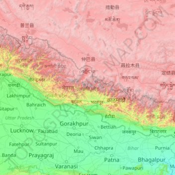
Name: Nepal topographic map, elevation, terrain.
Location: Nepal (26.34776 80.05708 30.44695 88.20153)
Average elevation: 2,604 m
Minimum elevation: 20 m
Maximum elevation: 8,152 m
Other topographic maps
Click on a map to view its topography, its elevation and its terrain.
Athens
Greece > Attica > Regional Unit of Central Athens
The southern section of the Athens metropolitan area (i.e., Elliniko) lies in the transitional zone between Mediterranean (Csa) and hot semi-arid climate (BSh), with its port-city of Piraeus being the most extreme example, receiving just 331.9 millimetres (13.07 in) per year. The areas to the south generally…
Average elevation: 168 m
Maunatlala
As time passed by Kgosi Mapena’s eldest son who was named Maunatlala died, the village’ name was changed from Kopung to Maunatlala. Climatic Conditions The climate of Maunatlala area is semi-arid with dry winters and fairly wet summer months, with drought endemic. The average precipitation for the area is…
Average elevation: 878 m
Gaborone
Botswana > South-East District
Gaborone is situated at 24°39′29″S 25°54′44″E / 24.65806°S 25.91222°E / -24.65806; 25.91222 between Kgale and Oodi Hills, on the Notwane River in the south-eastern corner of Botswana, and 15 kilometres (9.3 mi) from the South African border The city lies at an elevation of 1,010 metres…
Average elevation: 1,032 m
Гојна гора
Serbia > Moravica Administrative District > Gornji Milanovac Municipality > Gojna Gora
Average elevation: 613 m
Serule
Botswana > Central District > Serule
The population according to the 2001 census was 2,268 and it is estimated at more than 3000 in the latest 2011 census. The people of Serule Village comprises different ethnicities namely Bangwato, Bakwena, Batalaote, Bakalanga, Bahurutshe and its six wards are Mothoathubega, Borotsi, Mokwena, Botalaote,…
Average elevation: 935 m
Mbombela (Nelspruit)
South Africa > Mpumalanga > Ehlanzeni District Municipality
Average elevation: 842 m
Table Mountain
South Africa > Western Cape > City of Cape Town > Cape Town
Table Mountain is at the northern end of a sandstone mountain range that forms the spine of the Cape Peninsula that terminates approximately 50 kilometres (30 mi) to the south at the Cape of Good Hope and Cape Point. Immediately to the south of Table Mountain is a rugged "plateau" at a somewhat lower elevation…
Average elevation: 578 m
Mumbai
Mumbai is on a narrow peninsula located on the Salsette Island, which is bound by the Arabian Sea to the west, Thane Creek to the east, and Vasai Creek to the north. It lies at the mouth of the Ulhas River on the western coast of India, in the Konkan region. It shares the Salsette Island, with the Thane…
Average elevation: 13 m
Islamabad
Pakistan > Islamabad Capital Territory
Islamabad's micro-climate is regulated by three artificial reservoirs: Rawal, Simli, and Khanpur Dam. The latter is located on the Haro River near the town of Khanpur, about 40 kilometres (25 mi) from Islamabad. Simli Dam is 30 kilometres (19 mi) north of Islamabad. 220 acres (89 ha) of the city consists of…
Average elevation: 666 m
Antrogna
Italy > Piedmont > Verbano-Cusio-Ossola > Calasca-Castiglione > Calasca
Average elevation: 979 m
Lima
The suburban district of Cieneguilla, the district of Pachacámac and the district of Chosica provide important tourist attractions among locals. Due to its elevation (over 500 masl), the sun shines in Chosica during the winter, being very visited by the residents of Lima to escape the urban fog.
Average elevation: 236 m
Mogadishu
Somalia > Banaadir > Hamar Weyne District
Mogadishu is located in or near the tropical thorn woodland biome of the Holdridge global bioclimatic scheme. The mean temperature in the city year-round is 27 °C (81 °F), with an average maximum of 30 °C (86 °F) and an average minimum of 24 °C (75 °F). Mean temperature readings per month vary by 3 °C…
Average elevation: 43 m
Nuuk
Nuuk also has the Godthåbhallen, a handball stadium. It is the home of the Greenland men's national handball team and has a capacity of 1,000. There is a hill for alpine skiing with an altitude difference around 300 meters on the mountain Lille Malene, with the valley station close to the airport terminal.…
Average elevation: 76 m
Quito
Quito's elevation of 2,850 meters (9,350 ft) makes it either the highest or the second-highest national capital city in the world. This varied standing is because Bolivia is a country with multiple capitals; if La Paz is considered the Bolivian national capital, it tops the list of highest capitals, but if…
Average elevation: 2,930 m
Santiago
Chile > Santiago Metropolitan Region > Provincia de Santiago
The city lies in the center of the Santiago Basin, a large bowl-shaped valley consisting of broad and fertile lands surrounded by mountains. The city has a varying elevation, gradually increasing from 400 meters (1,300 feet) in the western areas to more than 700 m (2,297 ft) in the eastern areas. Santiago's…
Average elevation: 722 m
Ankara
Ankara has a cold semi-arid climate under the Köppen climate classification (BSk), while under the Trewartha climate classification, the city is classified as humid continental (Dc). Due to its elevation and inland location, Ankara has cold and snowy winters, and hot and dry summers. Rainfall occurs mostly…
Average elevation: 1,082 m
Antananarivo
Antananarivo (Malagasy: [antananaˈrivʷ]; French: Tananarive, pronounced [tananaʁiv]), also known by its colonial shorthand form Tana (pronounced [tana]), is the capital and largest city of Madagascar. The administrative area of the city, known as Antananarivo-Renivohitra ("Antananarivo-Mother Hill" or…
Average elevation: 1,309 m
Allingtown
United States > Connecticut > South Central Connecticut Planning Region > West Haven
Average elevation: 26 m
Simikot
Nepal > Karnali Province > Humla
Lying at an altitude of just over 2,900 metres or 9,500 feet on a gentle slope high above the Humla Karnali River, Simikot lies on an ancient trade-cum-pilgrimage route to Mount Kailash. Mount Kailash is located in the Purang County of the Tibetan Autonomous Region, China, which borders Humla district of Nepal…
Average elevation: 3,100 m
Burgersfort
South Africa > Limpopo > Sekhukhune District Municipality > Greater Tubatse Local Municipality
Average elevation: 810 m
Kilimanjaro
The mountain was incorporated into Kilimanjaro National Park in 1973. As one of the Seven Summits, Kilimanjaro is a major hiking and climbing destination. There are seven established routes to Uhuru Peak, the mountain's highest point. Although not as technically challenging as similar mountains, the prominence…
Average elevation: 1,537 m
Marloth Park
South Africa > Mpumalanga > Ehlanzeni District Municipality > Nkomazi
Average elevation: 220 m
Velddrif
South Africa > Western Cape > West Coast District Municipality > Bergrivier Local Municipality
Average elevation: 8 m
Nordegg
Canada > Alberta > Clearwater County
Nordegg has a subarctic climate (Dfc) which can be considered a subalpine climate due to its altitude with locations on the same latitude having warmer climates. Summers are mild, with a few warm days sprinkled in here and there, while winters are cold and snowy.
Average elevation: 1,475 m