
Make a donation
Delaware topographic map
Click on the map to display elevation.
Make a donation
Delaware
Delaware is on a level plain, with the lowest mean elevation of any state in the nation. Its highest elevation, located at Ebright Azimuth, near Concord High School, is less than 450 feet (140 m) above sea level. The northernmost part of the state is part of the Piedmont Plateau with hills and rolling surfaces.
Make a donation
About this map
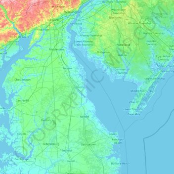
Name: Delaware topographic map, elevation, terrain.
Location: Delaware, United States (38.45118 -75.78902 39.83943 -74.98494)
Average elevation: 16 m
Minimum elevation: -4 m
Maximum elevation: 205 m
Make a donation
Other topographic maps
Click on a map to view its topography, its elevation and its terrain.
Make a donation
Make a donation
Mount Shasta
United States > California > Siskiyou County
Mount Shasta (/ˈʃæstə/ SHASS-tə; Shasta: Waka-nunee-Tuki-wuki; Karuk: Úytaahkoo) is a potentially active stratovolcano at the southern end of the Cascade Range in Siskiyou County, California. At an elevation of 14,179 ft (4,322 m), it is the second-highest peak in the Cascades and the fifth-highest in…
Average elevation: 3,717 m
Make a donation
Make a donation
Lake Koon
United States > Pennsylvania > Bedford County > Cumberland Valley Township
Average elevation: 366 m
Cherry Grove Beach
United States > South Carolina > Horry County > North Myrtle Beach
Average elevation: 1 m
Make a donation
Hoover Dam
United States > Arizona > Mohave County
The amount of electricity generated by Hoover Dam has been decreasing along with the falling water level in Lake Mead due to the prolonged drought since year 2000 and high demand for the Colorado River's water. By 2014 its generating capacity was downrated by 23% to 1592 MW and was providing power only during…
Average elevation: 429 m
Make a donation
Totoket Mountain
United States > South Central Connecticut Planning Region > North Branford
Average elevation: 119 m
Make a donation
Make a donation
Elk Creek
United States > California > Glenn County > Elk Creek
Elk Creek is a census-designated place in Glenn County, California. It is located 19 miles (31 km) northwest of Willows, at an elevation of 745 feet (227 m).
Average elevation: 258 m
Worley Crossroads
United States > Georgia > Cherokee County > Worley Crossroads
Average elevation: 378 m
Cleveland
United States > Ohio > Cuyahoga County > Cleveland
The land rises quickly from the lake shore elevation of 569 feet. Public Square, less than one mile (1.6 km) inland, sits at an elevation of 650 feet (198 m), and Hopkins Airport, 5 miles (8 km) inland from the lake, is at an elevation of 791 feet (241 m).
Average elevation: 221 m
Make a donation
Mountain City
United States > Tennessee > Johnson County > Mountain City
Mountain City is a town in, and the county seat of Johnson County, Tennessee, United States. The population was 2,383 at the 2000 census and 2,531 at the 2010 census. It is the northeasternmost county seat in Tennessee. In addition, at an elevation of 2,418 feet (737 m), it has the distinction of being the…
Average elevation: 851 m
Make a donation
Atlantic Coastal Plain
United States > North Carolina > Cumberland County > Fayetteville
The province's average elevation is less than 900 meters above sea level and extends some 50 to 100 kilometers inland from the ocean. The coastal plain is normally wet, including many rivers, marsh, and swampland. It is composed primarily of sedimentary rock and unlithified sediments and is primarily used for…
Average elevation: 51 m
Make a donation
Lyme Highest Point
United States > Connecticut > Lower Connecticut River Valley COG > Lyme
Average elevation: 88 m