
Make a donation
Europe topographic map
Click on the map to display elevation.
Make a donation
Europe
Europe's topography is characterized by a striking contrast between its rugged southern mountains and the expansive plains of the north. The continent is often described as a "peninsula of peninsulas," featuring major peninsulas like the Iberian, Italian, and Balkan, each with unique geological features. In the southern regions, mountain ranges such as the Alps and the Pyrenees rise dramatically, with elevations frequently exceeding 9,800 feet (3,000 meters). Moving northward, the terrain gradually descends into the Great European Plain, a vast lowland stretching from the Pyrenees in the west to the Ural Mountains in the east, where most elevations are below 1,640 feet (500 meters). This plain is interspersed with rolling hills and valleys, making it one of the most agriculturally productive areas in Europe, while also being historically significant due to its accessibility for trade and invasion. The northern regions, including Scandinavia and the British Isles, are marked by fjords and rugged uplands, contributing to a diverse and complex landscape across the continent.
Make a donation
About this map
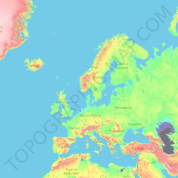
Name: Europe topographic map, elevation, terrain.
Location: Europe (26.00000 -15.00000 76.00000 35.00000)
Average elevation: 223 m
Minimum elevation: -30 m
Maximum elevation: 3,987 m
Make a donation
Other topographic maps
Click on a map to view its topography, its elevation and its terrain.
Serbia
Ancient mountains in the southeast corner of the country belong to the Rilo-Rhodope Mountain system. Elevation ranges from the Midžor peak of the Balkan Mountains at 2,169 metres (7,116 feet) (the highest peak in Serbia, excluding Kosovo) to the lowest point of just 17 metres (56 feet) near the Danube river…
Average elevation: 492 m
Saint Croix
United States > United States Virgin Islands > Saint Croix District > Christiansted
Average elevation: 11 m
Nepal
Nepal is divided into three principal physiographic belts known as Himal–Pahad–Terai. Himal is the mountain region containing snow and situated in the Great Himalayan Range; it makes up the northern part of Nepal. It contains the highest elevations in the world including 8,848.86 metres (29,032 ft) height…
Average elevation: 2,604 m
Make a donation
Zurich
Switzerland > Zurich > District Zurich
On its west side, the Limmat valley is flanked by the wooded heights of the Albis chain, which runs along the western border. The Uetliberg is, with 869 m (2,851 ft) above sea level, the highest elevation of the surrounding area. Its summit can be reached easily by the Uetlibergbahn. From the platform of the…
Average elevation: 499 m
Borneo
Before sea levels rose at the end of the last Ice Age, Borneo was part of the mainland of Asia, forming, with Java and Sumatra, the upland regions of a peninsula that extended east from present day Indochina. The South China Sea and Gulf of Thailand now submerge the former low-lying areas of the peninsula.…
Average elevation: 141 m
Make a donation
Make a donation
Botswana
Botswana (/bɒtˈswɑːnə/ (listen), also UK: /bʊt-, bʊˈtʃw-/), officially the Republic of Botswana (Setswana: Lefatshe la Botswana, [lɪˈfatsʰɪ la bʊˈtswana]), is a landlocked country in Southern Africa. Botswana is topographically flat, with approximately 70 percent of its territory being the…
Average elevation: 1,078 m
Make a donation
Nairobi National Park
Kenya > Nairobi County > Kajiado North > Nairobi
The park covers an area of 117.21 km2 (45.26 sq mi) and is small in comparison to most of Africa's national parks. The park's altitude ranges between 1,533 and 1,760 m (5,030 and 5,774 ft). It has a dry climate. The park is the only protected part of the Athi-Kapiti ecosystem, making up less than 10% of this…
Average elevation: 1,662 m
New Jersey
High Point in Montague Township, Sussex County is the state's highest elevation at 1,803 feet (550 m) above sea level. The state's highest prominence is Kitty Ann Mountain in Morris County, rising 892 feet (272 m). The Palisades are a line of steep cliffs on the west side of the Hudson River in Bergen and…
Average elevation: 72 m
Gaborone
Gaborone is situated at 24°39′29″S 25°54′44″E / 24.65806°S 25.91222°E / -24.65806; 25.91222 between Kgale and Oodi Hills, on the Notwane River in the south-eastern corner of Botswana, and 15 kilometres (9.3 mi) from the South African border. The city lies at an elevation of 1,010 metres…
Average elevation: 1,034 m
Make a donation
Nahoon River
South Africa > Eastern Cape > Buffalo City Metropolitan Municipality > KuGompo City
Average elevation: 65 m
Make a donation
Bienville Parish
The highest natural point in Louisiana, a hill known as Mt. Driskill, 535 feet (163 m) in elevation, is located in north central Bienville Parish. The mountain is located on private land with public access by walking trail. It is named for James Christopher Driskill, a 19th-century landowner. Nearby is Jordan…
Average elevation: 72 m
Make a donation
Make a donation
Make a donation
Make a donation
North-East District
Most parts of Botswana have tableland slopes sliding from east to west. It is predominantly savannah, with tall grasses, bushes, and trees. The region has an average elevation of around 915 m (3,002 ft) above sea level. The annual precipitation is around 65 cm (26 in), most of which is received during the…
Average elevation: 1,077 m
Make a donation
Make a donation
Crow Wing County
Crow Wing County has two state forests, the Crow Wing State Forest and the Emily State Forest. The Cuyuna Lakes State Trail lies in the Upper Mississippi River Basin. The topography is gently rolling to flat, mostly wooded and heavily dotted with waters and wetlands. It is home to an abundance of wildlife,…
Average elevation: 386 m
Make a donation
Alleghany County
United States > North Carolina
Due to its elevation, Alleghany County enjoys slightly cooler summers than the lowland areas to the east and south, with temperatures seldom rising over 90 °F (32 °C). In the winter, however, temperatures can frequently be colder than would be expected in a southern state. Daytime highs can fall into the…
Average elevation: 754 m
Make a donation
Make a donation
Columbia River
The Deschutes River joins the Columbia near The Dalles. Between The Dalles and Portland, the river cuts through the Cascade Range, forming the dramatic Columbia River Gorge. Via the gorge, the Columbia crosses the Cascades at a lower elevation than any other river. The gorge is known for its strong and steady…
Average elevation: 1,055 m
Make a donation
Barajevo
Serbia > City of Belgrade > Barajevo Urban Municipality
The municipality is located in the lower northern part of Šumadija, southeast of the Belgrade, with an elevation spanning from 140 meters to 364 meters. Most of the municipal territory belongs to the drainage area of the Turija river, right tributary of the Peštan river, which in turn flows into the…
Average elevation: 221 m
Kweneng District
Kweneng is the only district without a foreign border. It borders Central District in northeast, Kgatleng District on the east, South-East District in southeast, Southern District in south, Kgalagadi District in the west, Ghanzi District in the north. The region is traversed by the northwesterly line of equal…
Average elevation: 1,083 m
Make a donation
San Diego County
San Diego County has a varied topography. On its western side is more than 70 miles (113 km) of coastline. Most of San Diego between the coast and the Laguna Mountains consists of hills, mesas, and small canyons. Snow-capped (in winter) mountains rise to the east, with the Sonoran Desert farther to the east.…
Average elevation: 544 m
Churchill County
The terrain of Churchill County consists of rugged mountainous ridges, dotted with lakes and ponds. The county's east and west sides are higher than the intermediate valley; its highest point around the county periphery is a ridge on the lower east boundary line, at 9,380 ft (2,860 m) ASL. The county has an…
Average elevation: 1,476 m
Make a donation
Make a donation
Make a donation
Los Angeles
United States > California > Los Angeles County
Los Angeles is characterized by a diverse and dynamic topography. The city is predominantly situated in a basin bordered by mountain ranges, including the Santa Monica Mountains to the north and the San Gabriel Mountains to the east, with elevations reaching up to about 10,000 feet (3,048 meters) in certain…
Average elevation: 241 m
Make a donation
Contra Costa County
In prehistoric times, particularly the Miocene epoch, portions of the landforms now in the area (then marshy and grassy savanna) were populated by a wide range of now extinct mammals, known in modern times by the fossil remains excavated in the southern part of the county. In the northern part of the county,…
Average elevation: 108 m
North-West District
The region has an average elevation of around 915 m (3,002 ft) above the mean sea level. The vegetation type is Savannah, with tall grasses, bushes and trees. The annual precipitation is around 650 mm (26 in), most of which is received during the summer season from November to May.
Average elevation: 979 m
Southern District
In the south, Southern borders the North West Province of South Africa. Domestically, it borders South-East District in east, Kweneng District in north, Kgalagadi District and south west. Southern District is traversed by the northwesterly line of equal latitude and longitude. Most part of Botswana has…
Average elevation: 1,139 m
Central District
Most part of Botswana has tableland slopes sliding from east to west. The region has an average elevation of around 915 m (3,002 ft) above the mean sea level. The vegetation type is Savannah, with tall grasses, bushes and trees. The annual precipitation is around 65 cm (26 in), most of which is received during…
Average elevation: 1,006 m
Make a donation
Taplejung
Geographically Taplejung is a mountainous district where the world's third highest peak Kanchenjunga (8586 m) is located. It is situated at elevation ranging from 670 metres (2,200 ft) to 8,586 metres (28,169 ft) from sea level.
Average elevation: 3,894 m
Évora
Évora (altitude 300m) is situated in Alentejo, a large region of wide plains in the south of Portugal, bordered to the North by the Tagus River and to the South by the region of Algarve. The city is 140 km (87 mi) from the capital city Lisbon, and 80 km (50 mi) from Badajoz at the Spanish border. It is the…
Average elevation: 247 m
Dothan
United States > Alabama > Houston County
It is located in the Wiregrass region of southeastern Alabama, near both the Florida and Georgia state lines. The topography is generally flat and forested, with few small hills that gradually slope downward towards the Chattahoochee River to the east and the gulf coastal plain to the south.
Average elevation: 88 m
Make a donation
Make a donation
Make a donation