
甘河滩镇 topographic map
Interactive map
Click on the map to display elevation.
About this map
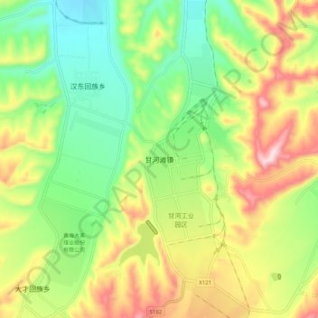
Name: 甘河滩镇 topographic map, elevation, terrain.
Location: 甘河滩镇, 湟中区, 西宁市, 青海省, 中国 (36.50624 101.47384 36.58624 101.55384)
Average elevation: 2,618 m
Minimum elevation: 2,467 m
Maximum elevation: 2,834 m
Other topographic maps
Click on a map to view its topography, its elevation and its terrain.