
海东镇 topographic map
Interactive map
Click on the map to display elevation.
About this map
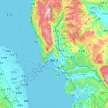
Name: 海东镇 topographic map, elevation, terrain.
Location: 海东镇, 大理市, 大理白族自治州, 云南省, 中国 (25.64823 100.21869 25.80344 100.37699)
Average elevation: 2,102 m
Minimum elevation: 1,960 m
Maximum elevation: 2,621 m
海东镇地势东高西低,南北排列着向阳、南村、上和三个坝子。最高点位于上登村东部,海拔2,700米,最低点位于向阳村洱海边,海拔1,965.5米。
Other topographic maps
Click on a map to view its topography, its elevation and its terrain.