
双廊镇 topographic map
Interactive map
Click on the map to display elevation.
About this map
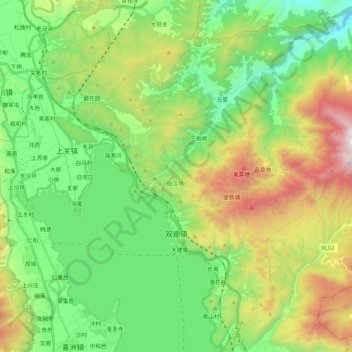
Name: 双廊镇 topographic map, elevation, terrain.
Location: 双廊镇, 大理市, 大理白族自治州, 云南省, 671009, 中国 (25.85063 100.16442 26.04135 100.35126)
Average elevation: 2,152 m
Minimum elevation: 1,603 m
Maximum elevation: 3,244 m
Other topographic maps
Click on a map to view its topography, its elevation and its terrain.