
Vestland topographic map
Interactive map
Click on the map to display elevation.
About this map
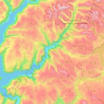
Name: Vestland topographic map, elevation, terrain.
Location: Årdal, Vestland, Norway (61.11088 7.37808 61.46120 8.25145)
Average elevation: 1,067 m
Minimum elevation: 0 m
Maximum elevation: 2,334 m
Other topographic maps
Click on a map to view its topography, its elevation and its terrain.
Finnmark
Finnmark, Bamble, Vestfold og Telemark, 3967, Norway
Average elevation: 38 m
Gaustatoppen
Gaustatoppen, Tinn, Vestfold og Telemark, 3660, Norway
Average elevation: 1,360 m
Gihtsejiegŋa
Gihtsejiegŋa, Nordkalottruta, Tysfjord, Nordland, Norway
Average elevation: 1,096 m
Folgefonna
Folgefonna, Gardshammar, Kvinnherad, Hordaland, Norway
Average elevation: 709 m