Geolocate

Nordland topographic map

Interactive map

Click on the map to display elevation.

Nordland

In the geological past, a collision with Greenland pushed long slices of the seabed on top of the existing bedrock, today forming the bedrock from Dovrefjell and Trollheimen south of Trondheim stretching north in Trøndelag and through Nordland to justh north of Tromsø. This Cambrian—Silurian bedrock, much of it mica schist, is by far the largest area in Norway with soft bedrock rich in nutritions good for plant growth. It forms the bedrock in the fjord areas, while the islands off the coast and some of the easternmost areas along the border with Sweden are made up of hard bedrock (usually granite). In some areas, as in Tysfjord and Sørfold, the bedrock is a mix of soft bedrock and hard granite. Much of the Lofoten mountains are of precambrian eruptive origin and 3.5 billion years old, among the oldest on earth. The youngest rock in Norway is on Andøya, also known for its fossils of dinosaurs and other life forms. As the land was depressed by the ice sheet in the ice age, substantial areas in the lowest altitudes was beneath the surface of the sea for thousands of years acquiring marine deposits. Due to post-glacial rebound, this is now dry land, reaching 120 metres (390 ft) above sea level today in Saltdal, 100 metres (330 ft) in Narvik and Brønnøysund, and 30 metres (98 ft) to 50 metres (160 ft) in Lofoten and Vesterålen. Limestone is very common in Nordland, with many caves throughout the county, such as Grønligrotta in Rana. There are more caves in Rana than any other area in northern Europe. In August 2006 the Tjoarvekrajgge cave in Sørfold was explored and verified as the longest cave in Scandinavia 22 kilometres (14 mi) long); Raggejavreraige in Tysfjord is the deepest in Scandinavia and Svarthamarhola in Fauske has the largest cavity. There are more than 900 caves in Nordland, one of these have a 70 metres (230 ft) high waterfall. Marble is found in several locations. Fauske is sometimes referred to as the marble capital, and has exported marble worldwide (one customer being the UN building in New York City).

Wikipedia (CC-BY-SA 3.0)

About this map

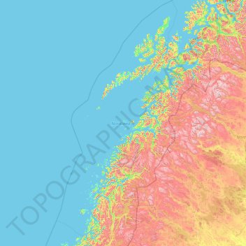
Name: Nordland topographic map, elevation, terrain.

Location: Nordland, Norway (64.93950 10.57806 69.59670 18.15135)

Average elevation: 259 m

Minimum elevation: -3 m

Maximum elevation: 1,940 m

Other topographic maps

Click on a map to view its topography, its elevation and its terrain.

Vassbygdevatnet

Norway > Vestland > Vassbygdi

Average elevation: 409 m

Rykkinn

Norway > Akershus

Average elevation: 138 m

Hjelle

Norway > Vestland

Average elevation: 401 m

Troms og Finnmark

Norway

Average elevation: 196 m

Hovden

Norway > Agder

Average elevation: 875 m

Vik

Norway > Vestland

Average elevation: 739 m

Rogaland

Norway

Average elevation: 275 m

Oslo

Norway

The lake's altitude above sea level is 183 metres. The water is in a popular hiking area. Near the water itself, it is great for barbecues, swimming, beach volleyball and other activities.

Average elevation: 233 m

Indre Østfold

Norway > Viken

Average elevation: 148 m

Finnmark

Norway > Vestfold og Telemark

Average elevation: 38 m

Andøy

Norway > Nordland

Average elevation: 31 m

Oppland

Norway > Nordland

Average elevation: 299 m

Jan Mayen

Norway

Jan Mayen consists of two geographically distinct parts. Nord-Jan has a round shape and is dominated by the 2,277 m (7,470 ft) high Beerenberg volcano with its large ice cap (114.2 km2 or 44 sq mi), which can be divided into twenty individual outlet glaciers. The largest of those is Sørbreen, with an area of…

Average elevation: 23 m

Trondheim

Norway > Trøndelag

Trondheim has a mild climate for its northerly latitude, resulting in moderate summers and winters that often remain above the freezing point in seaside areas. At higher elevations, though, the microclimate is colder and snowier.

Average elevation: 192 m

Sandnes

Norway > Rogaland

Average elevation: 523 m

Kristiansand

Norway > Agder

Average elevation: 76 m

Preikestolen

Norway > Vestland

Average elevation: 262 m

Nesbyen

Norway > Viken

Average elevation: 842 m

Gaustatoppen

Norway > Vestfold og Telemark

Average elevation: 1,360 m

Nordfjord

Norway

Average elevation: 59 m

Halti

Norway

Halti (Finnish: Halti, rarely Haltiatunturi, Northern Sami: Háldičohkka, Swedish: Halde fjäll) is a fell at the border between Norway and Finland. The peak (elevation 1,365 m (4,478 ft)) of the fell, called Ráisduattarháldi, is in Norway, on the border between the municipalities of Nordreisa and…

Average elevation: 1,192 m

Stadlandet

Norway

Average elevation: 281 m

Stavanger

Norway

Average elevation: 37 m

Bergen

Norway > Vestland > Bergen

Average elevation: 125 m

Kopperud

Norway > Kopperud

Average elevation: 121 m

Bøverdalen

Norway > Bøverdalen

Average elevation: 870 m

Blåhammaren

Norway

Average elevation: 504 m

Bømlo

Norway

Average elevation: 24 m

Karmoey

Norway

Average elevation: 16 m

Fly

Norway > Hernes

Average elevation: 493 m

Vestland

Norway

Average elevation: 1,067 m

Sør-Rokta

Norway

Average elevation: 214 m

Oppland

Norway > Oppland

Average elevation: 204 m

Rostad

Norway > Rostad

Average elevation: 44 m

Kjevik

Norway > Kjevik

Average elevation: 39 m

Bergenhus

Norway > Breiviken

Average elevation: 79 m

Hamn

Norway > Hamn

Average elevation: 88 m

Gihtsejiegŋa

Norway

Average elevation: 1,096 m

Senja

Norway

Average elevation: 144 m

Storskrymten

Norway

Average elevation: 1,699 m

Kvitøya

Norway

Average elevation: 95 m

Sæbyggjenuten

Norway

Average elevation: 1,328 m

Store memurutinden

Norway

Average elevation: 2,043 m

Møre og Romsdal

Norway

Average elevation: 868 m

Granberget

Norway > Oslo

Average elevation: 352 m

Storsylen

Norway

Average elevation: 1,375 m

Oppland

Norway

Average elevation: 1,195 m

Barents Island

Norway

Average elevation: 131 m

Beerenberg

Norway > Jan Mayen

Average elevation: 1,732 m

Folgefonna

Norway > Gardshammar

Average elevation: 709 m