
Thank you for supporting this site ❤️
Make a donation
Make a donation
Oslo topographic map
Click on the map to display elevation.
Thank you for supporting this site ❤️
Make a donation
Make a donation
Oslo
The lake's altitude above sea level is 183 metres. The water is in a popular hiking area. Near the water itself, it is great for barbecues, swimming, beach volleyball and other activities.
Thank you for supporting this site ❤️
Make a donation
Make a donation
About this map
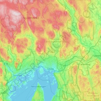
Name: Oslo topographic map, elevation, terrain.
Location: Oslo, Norway (59.80931 10.48917 60.13511 10.95139)
Average elevation: 233 m
Minimum elevation: -1 m
Maximum elevation: 682 m
Thank you for supporting this site ❤️
Make a donation
Make a donation
Other topographic maps
Click on a map to view its topography, its elevation and its terrain.
Thank you for supporting this site ❤️
Make a donation
Make a donation
Thank you for supporting this site ❤️
Make a donation
Make a donation