Geolocate

Vestland topographic map

Interactive map

Click on the map to display elevation.

About this map

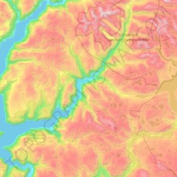
Name: Vestland topographic map, elevation, terrain.

Location: Årdal, Vestland, Norway (61.11088 7.37808 61.46120 8.25145)

Average elevation: 1,067 m

Minimum elevation: 0 m

Maximum elevation: 2,334 m

Other topographic maps

Click on a map to view its topography, its elevation and its terrain.

Fløyen

Norway > Vestland

Average elevation: 265 m

Rykkinn

Norway > Akershus

Average elevation: 138 m

Hjelle

Norway > Vestland

Average elevation: 401 m

Hovden

Norway > Agder

Average elevation: 875 m

Kristiansand

Norway > Agder

Average elevation: 76 m

Oppland

Norway > Nordland

Average elevation: 299 m

Finnmark

Norway > Vestfold og Telemark

Average elevation: 38 m

Preikestolen

Norway > Vestland

Average elevation: 262 m

Gaustatoppen

Norway > Vestfold og Telemark

Average elevation: 1,360 m

Rostad

Norway > Rostad

Average elevation: 44 m

Oppland

Norway > Oppland

Average elevation: 204 m

Sør-Rokta

Norway

Average elevation: 214 m

Fly

Norway > Hernes

Average elevation: 493 m

Blåhammaren

Norway

Average elevation: 504 m

Bøverdalen

Norway > Bøverdalen

Average elevation: 870 m

Kopperud

Norway > Kopperud

Average elevation: 121 m

Nordfjord

Norway

Average elevation: 59 m

Stadlandet

Norway

Average elevation: 281 m

Halti

Norway

Halti (Finnish: Halti, rarely Haltiatunturi, Northern Sami: Háldičohkka, Swedish: Halde fjäll) is a fell at the border between Norway and Finland. The peak (elevation 1,365 m (4,478 ft)) of the fell, called Ráisduattarháldi, is in Norway, on the border between the municipalities of Nordreisa and…

Average elevation: 1,192 m