
安宁市 topographic map
Interactive map
Click on the map to display elevation.
About this map
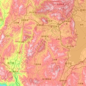
Name: 安宁市 topographic map, elevation, terrain.
Location: 安宁市, 昆明市, 云南省, 650300, 中国 (24.51761 102.16798 25.10404 102.62193)
Average elevation: 1,990 m
Minimum elevation: 1,183 m
Maximum elevation: 2,592 m
安宁地形呈东南高、西北低,有八街、连然、禄脿3个山间盆地,其余为山区半山区,属于乌蒙山余脉。最高点位于市境西南部与易门县交界处的黑风洞,海拔2617.7米,最低点在草铺街道王家滩村委会扒河出安宁境处的鲁家山河谷,海拔1680米。全市平均海拔1,800米。
Other topographic maps
Click on a map to view its topography, its elevation and its terrain.