
长湖镇 topographic map
Interactive map
Click on the map to display elevation.
About this map
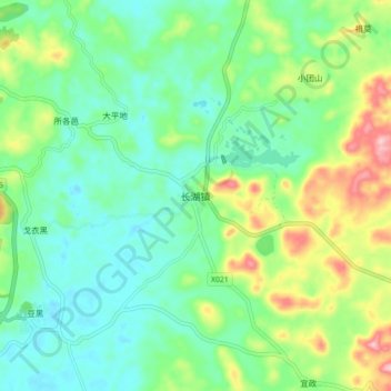
Name: 长湖镇 topographic map, elevation, terrain.
Location: 长湖镇, 昆明市, 云南省, 中国 (24.66892 103.36413 24.74892 103.44413)
Average elevation: 1,919 m
Minimum elevation: 1,861 m
Maximum elevation: 2,056 m
最高海拔2071米(窝子山)、最低1880米,地形为典型的喀斯特地貌,石岗岩为主等,还有长湖、圆湖等盆地。主要种植维小麦、烤烟、柿子等。长湖是传说中阿诗玛的故乡。
Other topographic maps
Click on a map to view its topography, its elevation and its terrain.