
滇池 topographic map
Interactive map
Click on the map to display elevation.
About this map
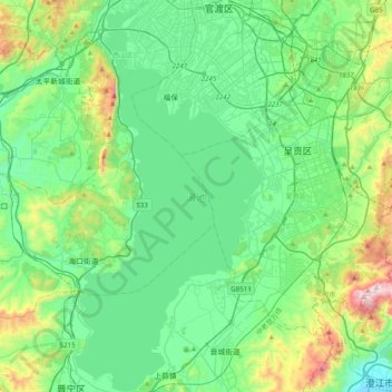
Name: 滇池 topographic map, elevation, terrain.
Location: 滇池, 昆明市, 云南省, 中国 (24.66893 102.59722 25.02428 102.78572)
Average elevation: 1,981 m
Minimum elevation: 1,746 m
Maximum elevation: 2,802 m
滇池也称昆明湖、昆明池,古称滇南泽,位于中國雲南省省会昆明市西南部,为云南省面积最大的高原淡水湖。湖泊海拔高度1886米。形状似胃形。湖底平坦。北部海埂湖堤以北称“草海”,以南称“外海”。
Other topographic maps
Click on a map to view its topography, its elevation and its terrain.