
New Brunswick topographic map
Interactive map
Click on the map to display elevation.
About this map
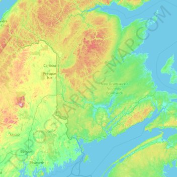
Name: New Brunswick topographic map, elevation, terrain.
Location: New Brunswick, Canada (44.28367 -69.05347 48.22068 -63.32887)
Average elevation: 152 m
Minimum elevation: -3 m
Maximum elevation: 1,412 m
Other topographic maps
Click on a map to view its topography, its elevation and its terrain.
West Lake Ainslie
Canada > Nova Scotia > Municipality of the County of Inverness
Average elevation: 119 m
Hamilton
Hamilton's climate is humid-continental, characterized by changeable weather patterns. In the Köppen classification, Hamilton it is on the Dfb/Dfa boundary, found in southern Ontario because the average temperature in July is 22.0 °C (71.6 °F). However, its climate is moderate compared with most of Canada.…
Average elevation: 187 m
Edmonton
Canada > Alberta > Division No. 11
Edmonton is on the North Saskatchewan River, at an elevation of 671 m (2,201 ft). It is North America's northernmost city with a population over one million. It is south of Alberta's geographic centre, which is near the Hamlet of Fort Assiniboine. The terrain in and around Edmonton is generally flat to gently…
Average elevation: 690 m
Area D (Sproat Lake)
Canada > British Columbia > Alberni-Clayoquot Regional District
Average elevation: 615 m
Vancouver Island
The rain shadow effect of the island's mountains, as well as the mountains of Washington's Olympic Peninsula, creates wide variation in precipitation. The west coast is considerably wetter than the east coast. Average annual precipitation ranges from 6,650 mm (262 in) at Hucuktlis Lake on the west coast…
Average elevation: 411 m
Barrier Islands
Canada > Ontario > Kenora District > Unorganized Kenora District
Average elevation: 345 m
McMurrich
Canada > Ontario > Parry Sound District > McMurrich/Monteith Township
Average elevation: 337 m
British Columbia
The Southern Interior cities of Kamloops and Penticton have some of the warmest and longest summer climates in Canada (while higher elevations are cold and snowy), although their temperatures are often exceeded north of the Fraser Canyon, close to the confluence of the Fraser and Thompson rivers, where the…
Average elevation: 708 m
Markham
Canada > Ontario > York Region > Markham
Markham's average altitude is at 200 m (660 ft) and in general consists of gently rolling hills. The city is intersected by two rivers; the Don River and Rouge River, as well as their tributaries. To the north is the Oak Ridges Moraine, which further elevates the elevation towards the north.
Average elevation: 216 m
Toronto
Despite its deep ravines, Toronto is not remarkably hilly, but its elevation does increase steadily away from the lake. Elevation differences range from 76.5 metres (251 ft) above sea level at the Lake Ontario shore to 209 m (686 ft) above sea level near the York University grounds in the city's north end at…
Average elevation: 140 m
Calgary
Calgary experiences a humid continental climate (Köppen climate classification Dwb) within eastern parts of the city and a subarctic climate (Köppen climate classification Dwc) within western parts of the city due to an increase in elevation. The city has warm summers and cold, dry winters. It falls into the…
Average elevation: 1,106 m
Carpenter Lake
Canada > British Columbia > Area A (Upper Bridge River Valley)
Average elevation: 1,592 m
Fort McMurray
Canada > Alberta > Fort McMurray
The community lies at a lower elevation than most other parts of Alberta, so under the right conditions it can be a "hot spot" for Alberta, or even all of Canada (as in April 1980 when its daily mean temperature of 10 °C (50 °F) was unsurpassed by any other Canadian station).
Average elevation: 345 m