
Cairngorm topographic map
Interactive map
Click on the map to display elevation.
About this map
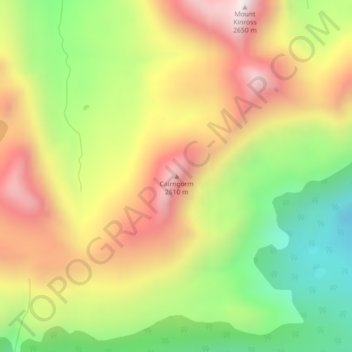
Name: Cairngorm topographic map, elevation, terrain.
Location: Cairngorm, Municipality of Jasper, Alberta, Canada (52.93305 -118.19065 52.93315 -118.19055)
Average elevation: 2,240 m
Minimum elevation: 1,828 m
Maximum elevation: 2,657 m
Other topographic maps
Click on a map to view its topography, its elevation and its terrain.
Edmonton
Canada > Alberta > Division No. 11
Edmonton is on the North Saskatchewan River, at an elevation of 671 m (2,201 ft). It is North America's northernmost city with a population over one million. It is south of Alberta's geographic centre, which is near the Hamlet of Fort Assiniboine. The terrain in and around Edmonton is generally flat to gently…
Average elevation: 690 m
Fort McMurray
Canada > Alberta > Fort McMurray
The community lies at a lower elevation than most other parts of Alberta, so under the right conditions it can be a "hot spot" for Alberta, or even all of Canada (as in April 1980 when its daily mean temperature of 10 °C (50 °F) was unsurpassed by any other Canadian station).
Average elevation: 345 m