
Calgary topographic map
Interactive map
Click on the map to display elevation.
Calgary
Calgary experiences a humid continental climate (Köppen climate classification Dwb) within eastern parts of the city and a subarctic climate (Köppen climate classification Dwc) within western parts of the city due to an increase in elevation. The city has warm summers and cold, dry winters. It falls into the NRC Plant Hardiness Zone 4a. According to Environment Canada, average daily temperatures in Calgary range from 16.5 °C (61.7 °F) in July to −6.8 °C (19.8 °F) in December.
About this map
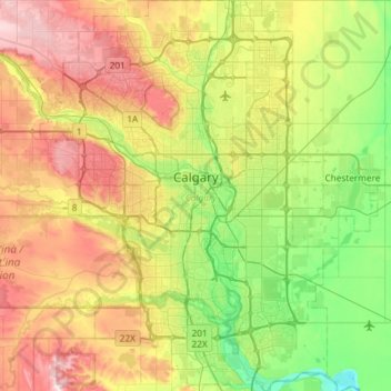
Name: Calgary topographic map, elevation, terrain.
Location: Calgary, Alberta, Canada (50.84253 -114.31576 51.21250 -113.86000)
Average elevation: 1,106 m
Minimum elevation: 957 m
Maximum elevation: 1,349 m
Other topographic maps
Click on a map to view its topography, its elevation and its terrain.