
Markham topographic map
Click on the map to display elevation.
Markham
Markham's average altitude is at 200 m (660 ft) and in general consists of gently rolling hills. The city is intersected by two rivers; the Don River and Rouge River, as well as their tributaries. To the north is the Oak Ridges Moraine, which further elevates the elevation towards the north.
About this map
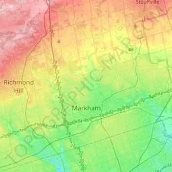
Name: Markham topographic map, elevation, terrain.
Location: Markham, York Region, Golden Horseshoe, Ontario, Canada (43.79804 -79.42873 43.96251 -79.17024)
Average elevation: 216 m
Minimum elevation: 135 m
Maximum elevation: 333 m