
留下街道 topographic map
Interactive map
Click on the map to display elevation.
About this map
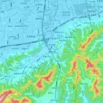
Name: 留下街道 topographic map, elevation, terrain.
Location: 留下街道, 西湖区, 杭州市, 浙江省, 310023, 中国 (30.19669 120.00052 30.27013 120.10657)
Average elevation: 76 m
Minimum elevation: 2 m
Maximum elevation: 450 m
Other topographic maps
Click on a map to view its topography, its elevation and its terrain.