
古荡街道 topographic map
Interactive map
Click on the map to display elevation.
About this map
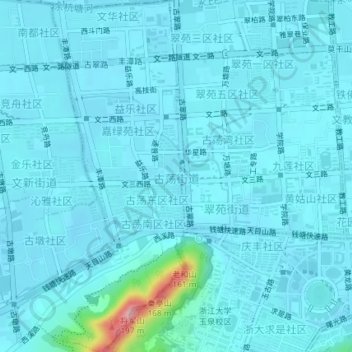
Name: 古荡街道 topographic map, elevation, terrain.
Location: 古荡街道, 西湖区, 杭州市, 浙江省, 中国 (30.26326 120.08927 30.29492 120.11493)
Average elevation: 16 m
Minimum elevation: 3 m
Maximum elevation: 166 m
Other topographic maps
Click on a map to view its topography, its elevation and its terrain.